Of the 102 cabins/homes at Sequoia Crest, 55 survived but unfortunately, not the original Rouch cabin built ca. 1946
By John Elliott for 3RNews, 2 October 2020.
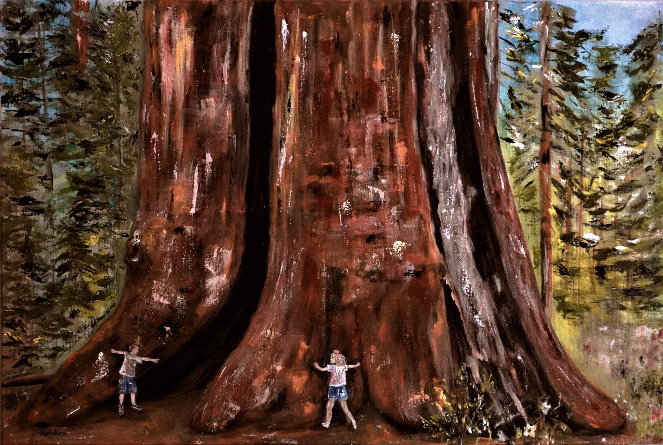
The SQF Complex Fire, that burned over Sequoia Crest and through the Alder Creek Grove, inspired artist Kerry Kaye Davies to create this painting of the Amos Alonzo Stagg Tree, the fifth largest Giant Sequoia on the planet. The Stagg Tree, recently purchased by the Save the Redwoods League, was one of only a handful of giant sequoias on privately owned land and the largest giant sequoia outside of Sequoia National Park.
“We sure have had a wonderful opportunity to have spent even a moment in our mountains. It’s hard to explain to someone the experience if they’ve never had it.” – Kerry Kaye Davies
Of the 102 cabins/homes at Sequoia Crest, 55 survived but unfortunately, not the original Rouch cabin built ca. 1946 Fire on the Mountain
In any disaster, and especially in this unprecedented fire season, there are hundreds of tragic stories. But for those who lose everything, and others whose homes are spared and return to desolation all around, their lives are forever changed.
Countless other persons are attached to these mountain communities across several generations whose lives were shaped by their time spent in these special places. Meet Kerry Kaye Davies, a mother of three, artist, photographer — her heart was broken the moment she heard about the SQF Fire burning in Sequoia Crest.
Davies 52, who now lives in Riverside, was immediately inspired to create a painting of the Amos Alonzo Stagg Tree. The Stagg Tree, see TKC article below, is the fifth largest giant sequoia in the world, and the centerpiece of Sequoia Crest, a cabin community nestled in the Alder Creek Grove of giant sequoias.
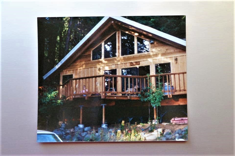
Sequoia Crest was a subdivision developed by Sonny Rouch in the years following WWII. The original Rouch cabin was built ca.1946 on Redwood Drive. With the end to logging in the area, it became the real estate office to sell other lots in the tract. After at least one other family owned the cabin, John and Hardie McFadden, parents of Kerry Kaye Davies, purchased the cabin in 1987 and owned it until 2009. During those years it was known as McFadden’s Cottage.
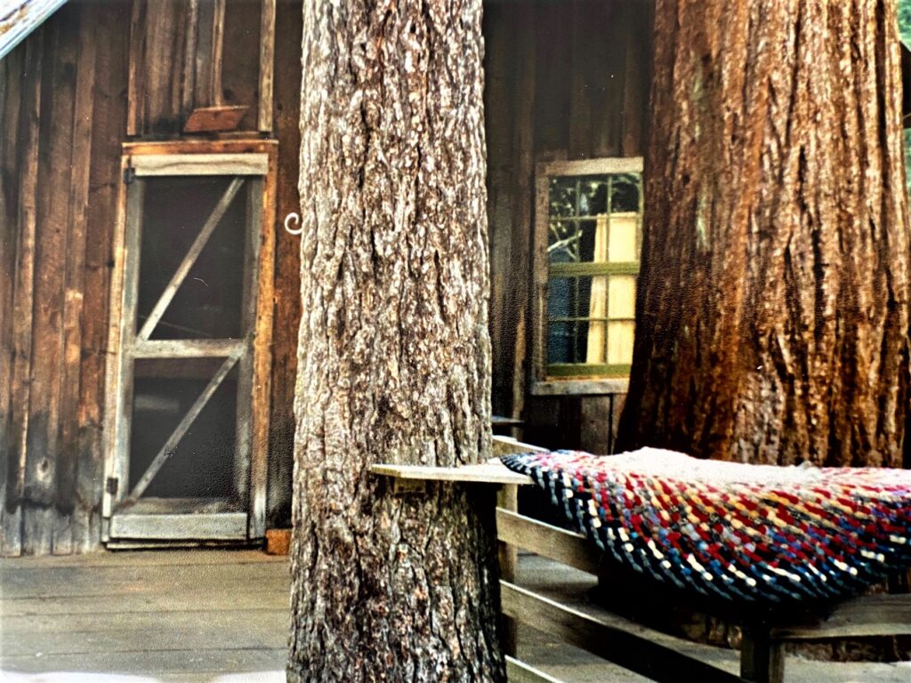
McFadden’s Cottage from 1987-2009. It was the original cabin built by Sonny Rouch ca. 1946 and later the real estate office to sell lots in the subdivision for mountain cabins. It was destroyed along with 46 other cabins in Sequoia Crest; 55 survived.
Kerry Kaye Davies in her own words:
Sequoia Crest won our hearts back early in the 1980’s I was barely a preteen taking art lessons with an art teacher who had a cabin in Sequoia Crest. They had invited our family up to their home and I immediately fell in love with the essence. I later got married and started a family and my parents bought their cabin in 1987 on Redwood Drive.
Kerry Kaye Davies, artist
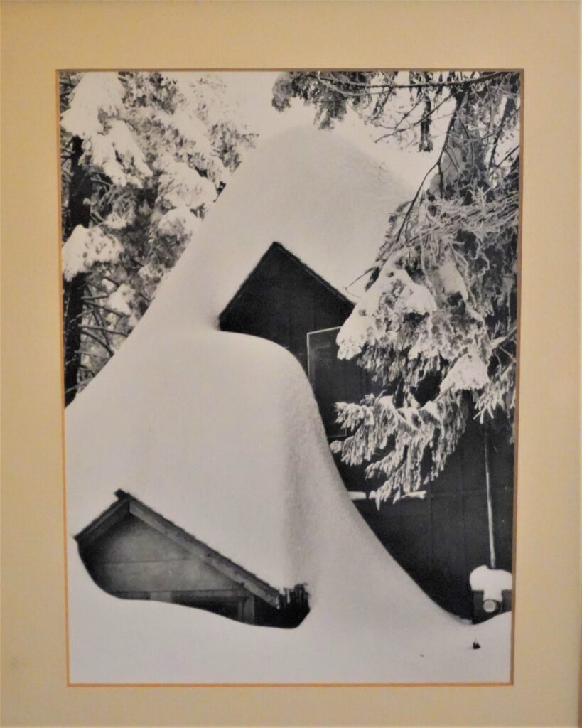
This began our family’s trips to the mountain, and our escape from the business of cities. My three sons and two nieces grew up visiting and living upon the Crest as this place became my parent’s retirement home. When they bought the cabin, it came with two old photographs evidence of a great storm season that had dropped a record snowfall.
There were many tales of that storm (late-1940s), although it wasn’t until 1997 that a measurable amount to match it landed on the Crest once again. My dad told me to take care of these photos because they are special, they were old when we got them, and yes they are indeed special.
Even though my parents did a major remodel of their cabin, the side door and window to the loft were kept the same as this photo. And it was that top window that became our room and our children’s when we visited. As you can see in the photos, it must have been quite a task to dig and to get in and out. I’ve had these photos hanging and in my possession for 30 years . And now, since the fire, they hold even greater significance for the several families who have graced this cabin’s life.
Sequoia Crest cabin covered with snow from an epic storm in the late-1940s.
There are special places upon the Crest — Jordan Peak, Poppy Lake, the Amos Alonzo Stagg Tree, and the embodiment of the Sequoia National Forest itself, that makes us migrate back making memories as evidence of the generations who care and love this mountain. Even though my parents did move several years ago (2009), for 23 years we called this place our second home.
Today, even though we live in cities and towns, our hearts never leave this special place once you have fallen in love with the Crest. You can’t open any of our family photo albums without having some photos of the cabin in them and the evolution of the growth of the kids.
“It feels like salt on a wound to think of the devastation”
Big trees and historic cabins were 2020 Castle Fire casualties in Sequoia’s Dillonwood Grove.
By Sarah Elliott and Laile Di Silvestro for 3RNews, 6 November 2020.
An aerial view of the aftermath of the Castle Fire in the Freeman Creek Grove of giant sequoias. (USDA photo by Curtis Kvamme)
The Dillonwood Grove of giant sequoias, at one time the largest privately owned stand of giant sequoia trees, is located 32 miles from Highway 198’s intersection with Yokohl Valley Road and 6 miles north of Balch Park. Although within an easy day trip of Three Rivers, the grove is the least visited area of Sequoia National Park that is accessible by road. A high-clearance vehicle is necessary to traverse the severely rutted, previously overgrown (but now the vegetation has burned), narrow access road, then it’s several more miles of hiking once the locked entrance gate is reached.
From logging to preservation
Logging started on the lower fringes of Dillonwood around 1865 and continued sporadically until about 1990. In 2001, Save the Redwoods League donated the 1,540-acre grove containing multi-generational giant sequoias to Sequoia National Park after a massive fundraising campaign to purchase the privately held grove. Big Trees and historic cabins
The nonprofit organization brokered a deal to purchase the grove to remove it from private hands and the threat of logging. The purchase price was $10 million. The League raised $5 million to match a $5 million grant approved by Congress that came from the federal Land and Water Conservation Fund.
At the time, Dillonwood Grove was owned by siblings David Reed and Susan Matthews, who inherited the land in the mid 1980s. Their parents, Forrest Reed, a professional forester, and Ruth Moore Reed, whose father worked for Pacific Lumber Company in Humboldt County, bought the land in 1960.
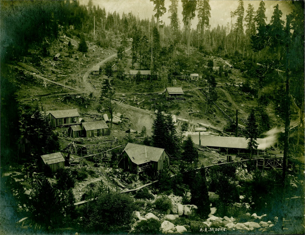
The Dillonwood logging settlement in 1904. Note what remains of a stand of large sequoias at top-center. The road to the left of the giant sequoias that curves down toward the center of the photo is a logging skid path. A “steam donkey engine” would drag cut trees along the skid to the sawmill. There’s a flume running from the sawmill (building at lower right) that was used to transport cut trees down the steep mountainside to Springville. (Photograph by A.R. Moore, Terry Ommen collection)
Giant sequoias and their nemeses
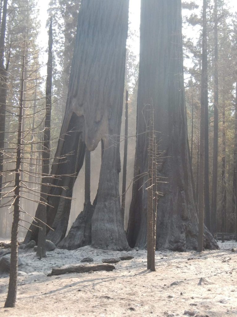
During a century or more of logging in the grove, many old-growth sequoias were felled. All but about 100 large giant sequoias were cut. But it was currently a thriving grove with subsequent generations of sequoias growing where their ancestors were cut and hauled away. And while logging will never occur again in the remote Dillonwood Grove, these Big Trees were recently confronted with another threat: high-severity fire. Big Trees and historic cabins
Even the oldest, largest giant sequoias are vulnerable to intense fire. Most of these ancient trees — at the headwaters of the North Fork of Tule River and bounded on three sides by Giant Sequoia National Monument — have lived through hundreds of fires since before the birth of Jesus Christ, yet modern wildfires are killing them. And while some giant sequoia seedlings will germinate after the fire, new seedlings will have difficulty competing with the shrubs that flourish in response to high-severity fire.
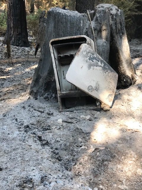
Historic structures decimated
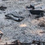
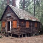
Left over from the Dillonwood logging days were some wooden structures that are now gone. Click on the before-and-after photos below to witness the destruction.
Two other historic cabins in other areas of the Golden Trout Wilderness were destroyed. The Mountain Home Guard Station was built by the Civilian Conservation Corps, ca. 1937-1938, and was in use recently as a recreational rental. The Grey Meadow Guard Station was completed in 1916 for a total construction cost of $90.
BEFORE – Board-and-batten cabin.
AFTER – Bedsprings and a stove are all that remain from the board-and-batten cabin. (Anthony Rocha photos)
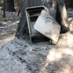
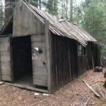
BEFORE – Shingled cabin.
AFTER – A burned-out shell of a vintage refrigerator is all that’s left of the shingled cabin.
BEFORE – The bunkhouse.
AFTER – No trace remains of the bunkhouse.
Dillonwood’s namesake
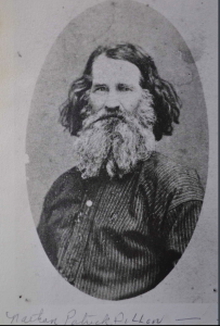
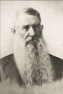
Nathaniel Dillon
Nathaniel Patrick Dillon (1820-1903) was one of the earliest Euro-American settlers in Tulare County. He arrived in 1853 with a few siblings, his wife Zylpha, and three children, one of whom was born en route. They initially entered into the incipient livestock industry and grew grain.
At some point in the 1860s, however, Nathan got into the milling business. His initial mills were gristmills, which converted the area’s corn and wheat into flour and made him one of the most wealthy men in the area.
Zylpha and Nathan had at least 12 children, nine of whom survived into adulthood. They also cared for Elliott and Mary Jane Dillon, the children of Nathan’s younger brother Peter Ewell, who were orphaned in 1866. After Zylpha died in 1886, Nathan remarried and had one more child before his second wife died after being thrown from a wagon while descending the mountain from Dillonwood.
Dillonwood was Nathan’s pinery, which he established in 1875. It is believed to have been his second lumber mill, the first having been established the prior year in Mineral King in the area now known as Faculty Flat. Nathan did not engage in mining in Mineral King, but instead panned for gold in the White River area, founded in 1856 as a gold camp. Originally called Dogtown, then Tailholt, the unincorporated Tulare County community is known today as White River. It is located about 10 miles east of Delano.
Nathaniel Dillon
Members of the Dillon family did stake Mineral King mine claims, however, and Dillonwood served as a wayside during the 1870s and 1880s for miners and adventurers traveling from the Tule River country to Mineral King. At one time, there were plans for the route from Dillonwood to be the main route to Mineral King.
One of the Mineral King miners was Nathan’s adopted niece Mary Jane Dillon, who staked a claim with Anna Mills shortly before Mary Jane was to marry Samuel Miles Gilliam (brother-in-law of Mineral King resort owner Arthur Crowley). Anna Mills was one of the most famous people to camp at Dillonwood. She did so in 1878 while on her way to climb Mount Whitney with the first party of women to reach the summit.
By the end of his life, Nathan was blind. However, his children tended him as well as his land.
Laile Di Silvestro of Three Rivers, historical archaeologist, provided the background on Nathaniel Dillon.
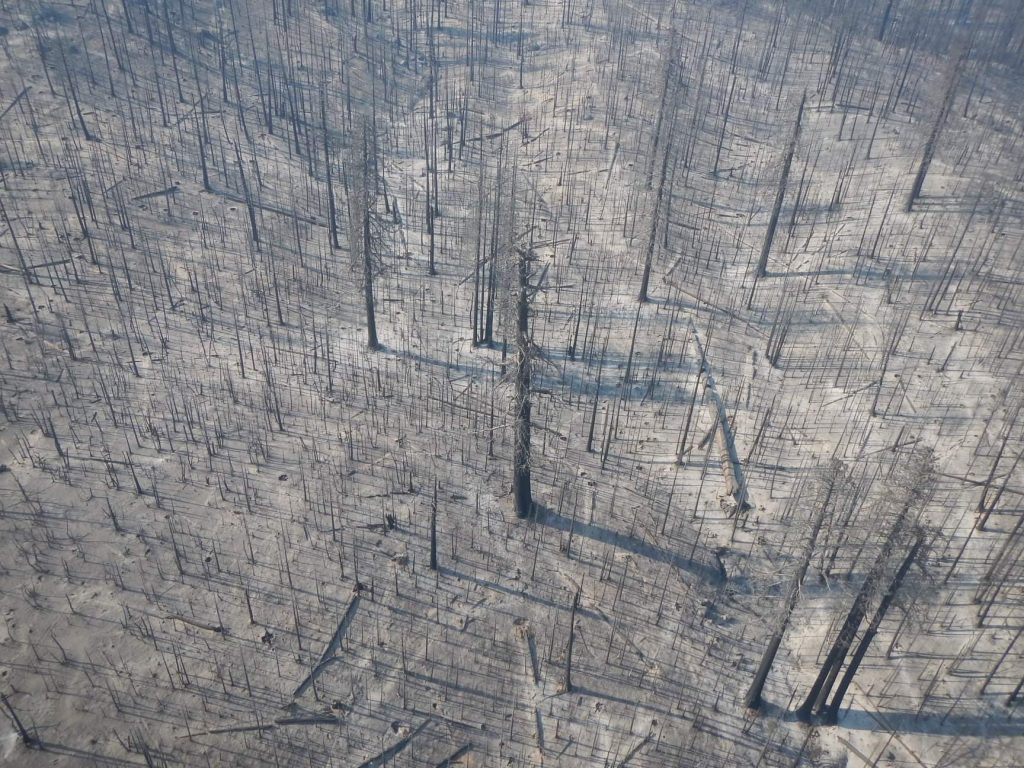
Castle Fire and the sequoia groves in its path
The 2020 Castle Fire burned an estimated 13,600 acres in 10 giant sequoia groves that are located within the Giant Sequoia National Monument of the Sequoia National Forest. Sequoia National Forest has 33 groves total within its boundaries. The Forest Service groves impacted were Alder Creek (shared with private landowner), Mountain Home (shared with State of California), Belknap Complex (McIntyre, Wheel Meadow, Belknap; shared with private landowner), Dillonwood (shared with National Park Service), Middle Tule (shared with State of California), Burro Creek, Freeman Creek, Silver Creek, Upper Tule, and Wishon groves.
Approximately 9,800 acres (35%) burned out of the 27,830 acres of giant sequoia groves in the Monument, with approximately 6,000 acres (61%) burning at high-severity. Where fire burned at lower-severity, or where high-severity patches were small, the fire is expected to have restorative effects on the groves by activating sequoia seedling growth, reducing fuel loads that could fuel future fires, and clearing out small trees leaving more water and light available for remaining plants and sequoia seedlings.
Giant sequoias are a fire-adapted species and need fire to regenerate. Forest fuels in many groves have dramatically changed from fire exclusion and the presence of drought-killed trees of other species, which influences how severely wildfire moves through them. Patches of high-severity fire in the 2020 Castle Fire were likely much larger than they would have been historically, and this could mean an uncertain future for portions of the groves.
The Forest Service will not be able to assess grove impacts until a thorough survey can be conducted. Preliminary satellite data indicate the highest losses of mature giant sequoia trees are in the Belknap Complex and the Freeman Creek groves. Of the recently burned groves, the U.S. Forest Service Burned Area Emergency Response Team found that Alder Creek, Belknap Complex, Dillonwood, and Freeman Creek groves burned at the highest severity, which implies there were also higher losses of trees in those groves.
Note: This article does not include an assessment of the impacts of the Castle Fire on giant sequoia groves within Sequoia National Park. In addition to Dillonwood, nine other sequoia groves in the park are within the Castle Fire’s perimeter: Garfield, Devils Canyon, Forgotten, Clough Cave, Putnam-Francis, South Fork, Cedar Flat, Board Camp, and Homers Nose groves.
Mature sequoias in the Freeman Creek Grove that were severely burned during the Castle Fire. (USDA photo by Curtis Kvamme)
The SQF complex fire destroyed the historic Jordan Peak Fire Lookout in September 2020.
By John Elliott for 3RNews, 8 October 2020.
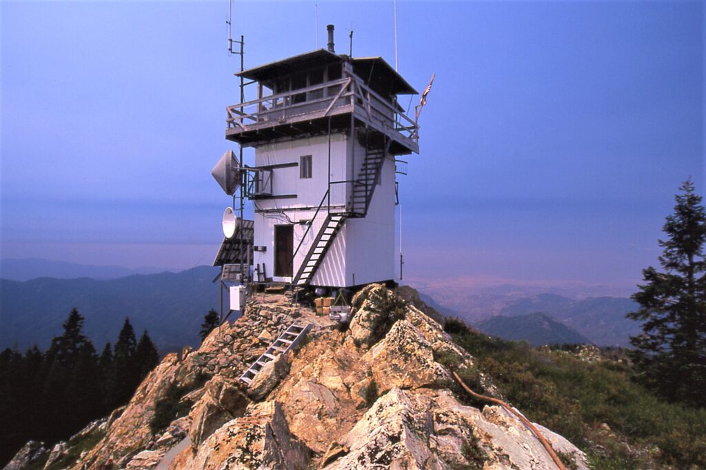
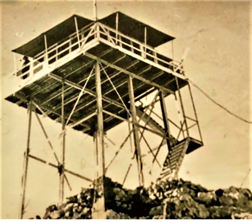
A recent image of the historic Jordan Peak Lookout — destroyed by the SQF Complex Fire on Monday, September 14, 2020. (Mathew Geer photo)
One of only four staffed lookouts left within Sequoia National Forest, the Jordan Peak Lookout was destroyed in a wind-driven firestorm on Monday, September 14, 2020. It is reportedly the oldest lookout site in the Sequoia National Forest.
The Early Years
The site was believed to have been used as a lookout in the 1890s prior to the land being designated as national forest. It was located on a granite peak at an elevation of 9,038 feet, a few miles north of Camp Nelson and northeast of Springville. Written accounts exist from 1899 where one observer reported that he could see a dozen fires burning the summer before from the promontory.
There is evidence that the site was officially used as a lookout observation post as early as 1914. In those days, a smoke chaser would ride on horseback to the peak and spot smoke and fires with binoculars then plot the locations on a map using a compass.
Jordan Peak Lookout, ca. 1914. (Photo: Buck Rock Foundation)
The Jordan Peak Lookout location shows up on the oversize 1916 Sequoia National Forest map printed in two sections — a north and a south sheet. It was the first definitive topo map of the Sequoia National Forest boundaries and it showed the location of a lookout at Jordan Peak, but was erroneously drawn in the wrong section.
The name Jordan came from the area’s storied association with John Jordan. Jordan did the route finding and laid out the Jordan Trail in 1861. The trail shortened the route to the Coso Silver Mines near Owens Lake on the Sierra’s east side.
The trail led up Yokohl Creek across the south end of Blue Ridge, up Bear Creek to near Balch Park, then onto Hossack Meadow on the south side of Jordan Peak. Thence on to Kern Flat on the Kern River crossing the main summit of the Sierra via Jordan Hot Springs and Monache Meadows. Portions are still in use today and because of the Jordan Trail, the Union Army had improved access to the Coso district during the Civil War ensuring that the valuable silver would not find it’s way into the Confederate treasury.
The effect on the Jordan Peak area was that many 19th century settlers found their way into the rugged high country around the trail both north and south, a number of whom stayed. It follows that the Jordan Peak Lookout developed a special relationship with those mountain communities that developed around Camp Nelson.
That relationship with the homes and cabins in the area was a special one as a trek up to the summit of Jordan Peak afforded the best views of the Tule River drainage. It was a must for any visitor to the area, and local residents visited the site often to view each changing season of the Tule River country. It was a sightseeing destination, along with the local giant sequoia groves when cabin guests came calling.
The CCCs modernize: An observation post becomes a fire lookout
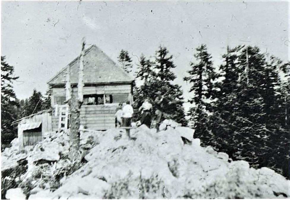
Jordan Peak Lookout in it’s post 1934 configuration. The steel tower with cab and catwalk was built by the CCCs — Rosevelt’s Civilian Conservation Corps. (Photo: Buck Rock Foundation)
As the years of the 20th century passed, the lookout assigned to Jordan Peak kept watch on a growing number of second homes and summer cabins that were developed in the area. The earliest construction of a 20-foot steel tower and L-4 cab with catwalk was completed in 1934 with the help of the CCCs (Roosevelt’s Civilian Conservation Corps). An extensive remodeling of the lookout structure was completed in 1970 when the existing tower and cab were enclosed with metal siding.
What resulted was a three-story, more utilitarian lookout. The top floor was the observation platform — communications center and work room — the middle floor was the sleeping quarters and at groud level was the kitchen and dining area.
Mark Thornton, an architectural historian who evaluated historic structures for the U.S. Forest Service, dismissed some of the historical significance owing to the 1970 remodeling, so Jordan Peak Lookout was determined not eligible for the National Register of Historic Places. However, the significance of the role that the lookout played in the local community and historical associations with the Jordan Trail, a case could certainly have been made today for a NR listing.
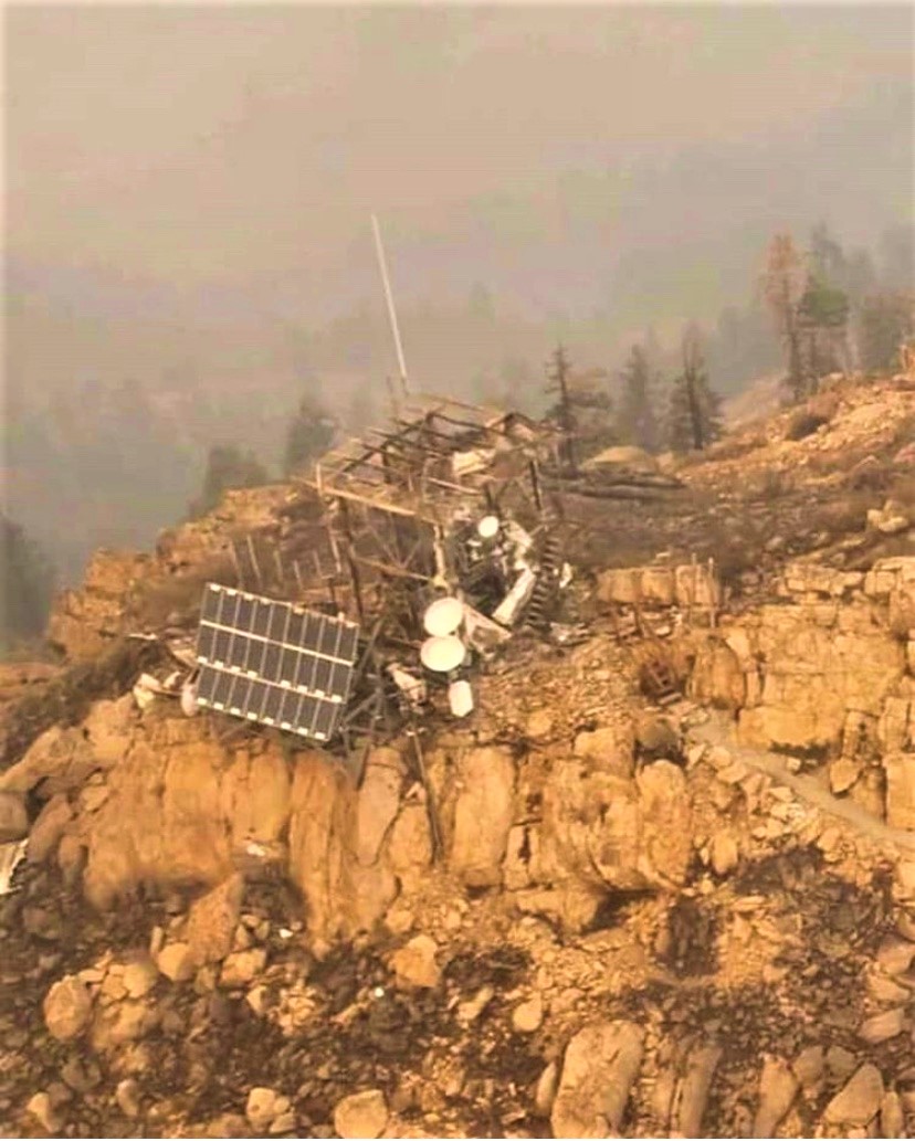
The SQF Complex fire ended any possibility of that ever happening. The lookout’s destruction by this epic wildfire underscores the need to protect cultural resources in advance of these intensifying fire seasons.
In 1994, the Jordan Peak Lookout was officially listed among 506 active and inactive fire lookouts in California by the Forest Fire Lookout Association. The lookout’s destruction on September 14 will be indelibly etched in the hearts and minds of all who knew and visited this special place.
All that remains of the historic Jordan Peak Lookout.
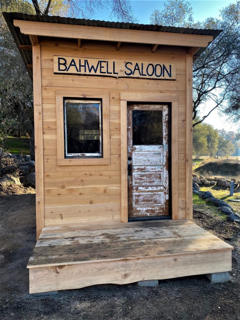
The Three Rivers Historical Society grounds hold a re-creation of what is believed to be the first public saloon in Three Rivers.
By Laile Di Silvestro. This article is partially based on a 14 January 2021 article by John Elliott for 3RNews.
In January of 2021, the Three Rivers Historical Society unveiled a re-creation of the Bahwell Saloon, believed to be the first public saloon in Three Rivers. The structure is 8’x16’ with a windows enabling visitors can look inside. The re-creation is based on a 1907 photo and data collected during an archaeological investigation. According to the investigators, the original saloon was located just 35 feet from the site of the re-creation, above the Bahwell Ditch.
A pit or small cellar found by the archaeologists suggests that water from a nearby spring may have been used to cool the beverages until 1896, when water from the new Bahwell ditch was used for the purpose.
Despite the archaeological evidence, the history of the Bahwell Saloon has been shrouded by time.
Local lore suggests that the structure in the 1907 photo was created in 1895 and lasted until Prohibition shut it down on July 1, 1919. Historic documentation, however, indicates that the Bahwell family had a hospitality business entailing alcohol sales by 1892, and may have established a wayside for travelers to Mineral King by 1888.
Adam Bahwell (1830-1901) was baptised Adamus Bahwel in the Duchy of Hesse in Napoleon Bonaparte’s empire (later in Prussia and now in Germany). He left Hesse in 1846 and arrived in California by 1847. He was just in time to join the earliest rush to northern California’s gold fields.
Reportedly penniless after his mining adventure, Adam moved to Visalia in 1859, where he married Nancy Atlantic Stephenson (1843-1892) in 1861. The two immediately commenced building a family and a large business empire.
Adam became a wheelwright, repairman, blacksmith, farmer, sheep rancher, citrus nurseryman, and mortgage lender with no qualms about collecting on debts. He and Nancy acquired a block of land in Visalia, where they built some of their businesses. Their blacksmith shop was famous for producing and selling the acclaimed Bahwell pruning shears.
They didn’t limit their sights to Visalia, however. Over time, they acquired farming and ranching property throughout the San Joaquin valley, primarily in Tulare County.
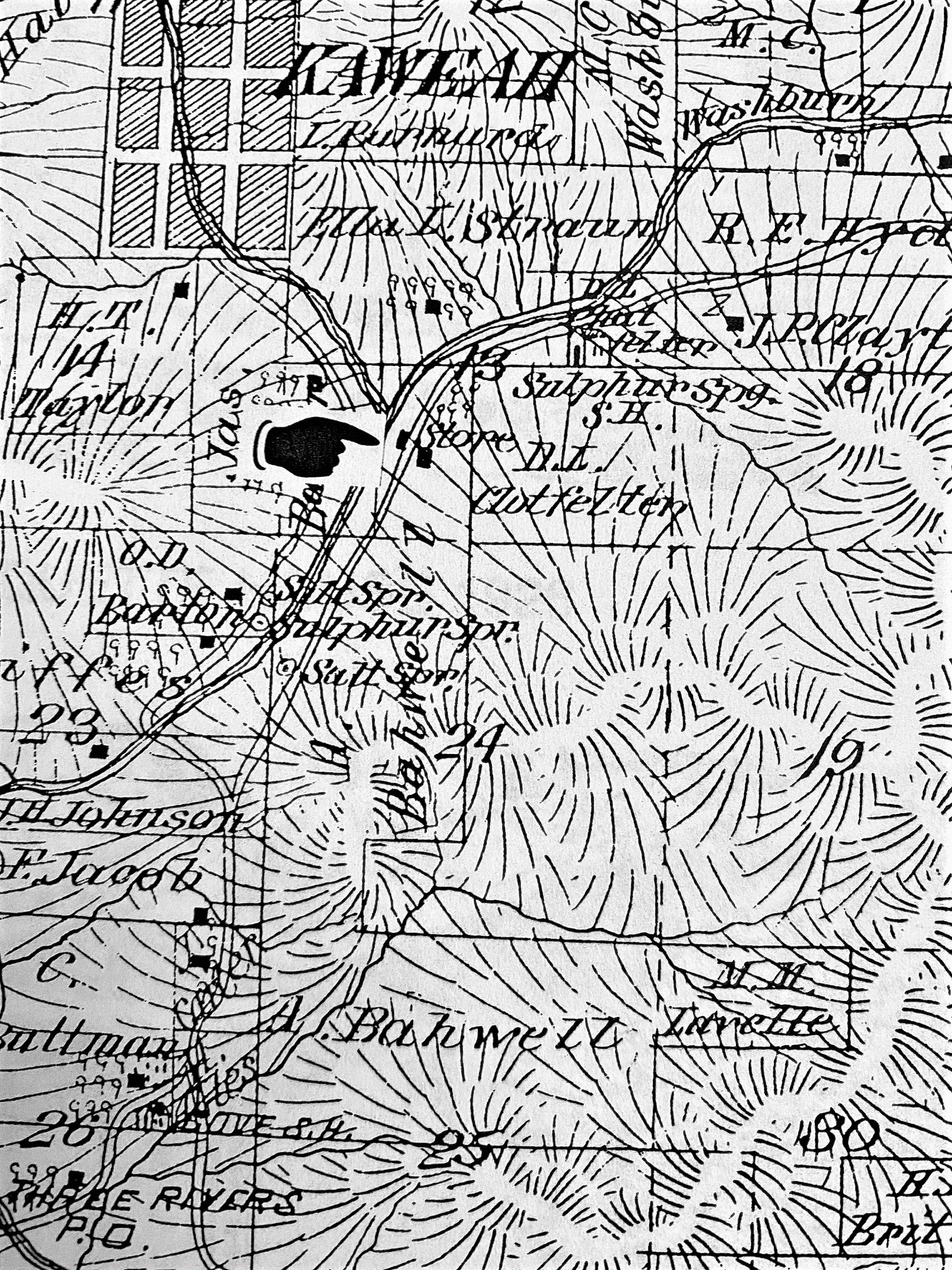
Detail of the Thompson 1992 atlas, p. 46.
One of these properties was a tract in Three Rivers, where the Bahwells built a home on the south side of the Kaweah River, across from the confluence of the North Folk and the Middle Fork and below a footbridge across the river. Records suggest that Nancy, Adam, and their six surviving children move there in 1880, but returned to their Visalia home in 1881.
According to official records, the Bahwells didn’t move to Three Rivers permanently until late 1884 at the earliest. A that point, they had added two more children to their family, and their oldest son, Charles Franklin “Charley”, had suffered a serious harvesting accident.
By 1888, “Bahwell’s” was a landmark. Geologists surveying the area used it as a point of reference, and noted that there was a house on the site. They didn’t mention a hotel, store, or saloon, but it is possible that Bahwell’s served as a wayside at that time.
Daily Delta (Visalia), 13 November 1892, p. 1.
By 1892, however, the new county map indicated that there was a store and house on the land, and a newspaper account indicates that the Bahwells were serving alcohol to the 4th Cavalry soldiers assigned to protect the new Sequoia National Park.
Nancy died at the end of 1892, but Adam and the children continued running the hospitality business. Perhaps due to his history as a tough lender, Adam’s reputation began to suffer. In 1893, Adam was accused of assaulting the wife of one of the 4th Cavalry soldiers, and news media declared him “a bad man.”
Daily Morning Delta, 17 August 1894, p. 1.
A newspaper report indicates that the Blossom family entered the roadside alcohol business in 1894, forcing the Bahwells to reduce the price of beer from 40 cents a bottle to 10 cents. The news media encouraged hungry and thirsty travelers to avoid Bahwell’s and buy from the Blossom family instead.
According to Forest Grunnigen (3RNews January 2021), the association of the saloon with the Bahwell family ended in the mid-1890s. According to official records, however. Adam Bahwell continued to run the hospitality business, and by 1900 considered his primary occupation that of hotel keeper.
By this time, Adam had become a very wealthy man. He was so wealthy, a young woman whom he had been wooing sued him for $25,000.00 for refusing to marry her. This is equivalent to $782,779.76 in spending power today.
Adam died in 1901 of dropsy (edema), and his son Charley inherited the property. It appears that Charley sold the saloon property within a decade.* At some point, according to local accounts, David F. Carter took it over.
According to local lore, the Bahwell Saloon survived WWI and the pandemic despite the growing prohibition movement. In November 1918, however, supply became an issue when the Wartime Prohibition Act banned the sale of beverages having an alcohol content greater than 1.28%. The 18th Amendment made the saloon’s demise final.
The saloon didn’t die quietly. Forest Grunnigen remembered having a beer at the saloon in July 1919 at the “grand closing party” when Prohibition became the law of the land.
*Confirmation of property transfers awaits the end of the 2019-2021 pandemic.
This thirsty cyclist, Philip Alles, stopped off in 1907 for some refreshment at the Bahwell Saloon (then purportedly Dave Carter’s place.). The more times change the more they remain the same. Three Rivers Historical Society photo
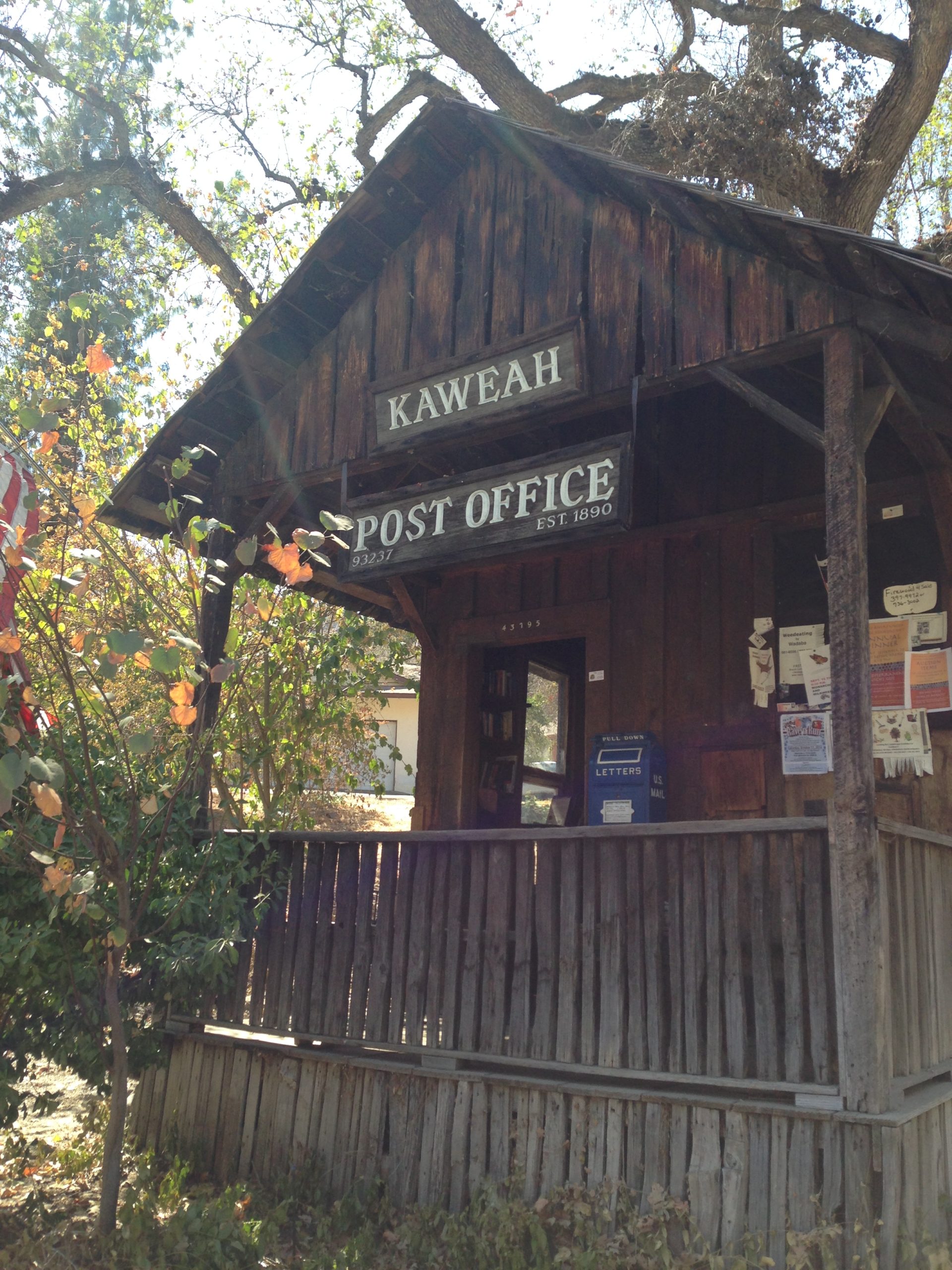
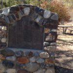
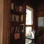
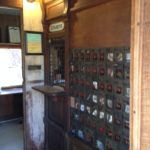
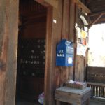
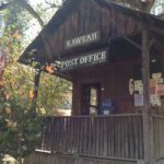
Once one of the smallest operating post offices in the United States, the Kaweah Post Office is a now a much-photographed destination that tells the story of adaptability after loss of a utopian dream.
This article is a compilation of multiple articles written by John and Sarah Elliott for The Kaweah Commonwealth on in 2015, 2016, and 2018 with an editorial update in in April 2021.
Almost daily, travelers make their way the three miles up North Fork Drive to visit the historic Kaweah Post Office. It is believed to be, in its own detached structure, the smallest continually operating post office in the United States.
In addition to being charming, the Kaweah Post Office has a remarkable story. It is one of the last vestiges of the Kaweah Cooperative Colony, a utopian project started in 1886 on the North Fork of the Kaweah River.
Part 1: History
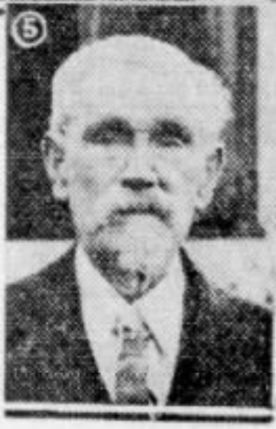
Charles F. Kellar. (Page 4C of the October 18, 1936 issue of the Fresno Bee.)
The Kaweah Post Office was initially established at Advance, the Kaweah Colony camp four miles farther up the North Fork than its current location. It was established in 1890, the same year Sequoia National Park was created. At that time, Robert Kellar was 14 years old. He was the son of Charles F. Kellar, one of the founders of the Kaweah Colony in 1885 and surveyor and foreman during construction of the Colony Mill Road from 1886 to 1888. Robert’s mother, Caroline, who was the camp cook, and his older brother Carl were also part of Colony life.
Although the Kellar family left Tulare County before the Colony dissolved in 1891, the family returned in 1905 and lived in Kaweah (next to the present-day location of the Post Office) until 1918. At the turn of the 20th century, Robert was a local rancher and builder.
At some point, the post office was later relocated to Redstone Ranch (present-day Riata Ranch). In 1910, Robert rebuilt the post office near its present location along North Fork Drive.
Robert’s descendants have record of Robert building both the Kaweah Post Office and Sulphur Springs School. The school building is now a private residence at 42612 Kaweah River Drive.
The Kellar family also has photographs and a contract showing Robert reconstructed the Marble Fork Bridge on the Crystal Cave Road in Sequoia National Park and the River Inn Bridge in Three Rivers (which spans the Middle Fork to provide access from Highway 198 to North Fork Drive).
In 1926, postmistress and librarian Ida Purdy asked for the post office to be moved 800 feet closer to her home, which then served as the library.
In 1948, California officially designated the Kaweah Post Office as State Registered Landmark No. 389 owing to its association with the Kaweah Co-operative Colony. A first-day cover was issued and 5,000 cachets were mailed to collectors.
In 1999 Kathleen McCleary purchased the property. Since then, she has owned the Kaweah Post Office building and, until 2010, leased it to the United States Postal Service.
The U.S. postal service terminated the full- service post office contract in May 2010.
Part 2: Preservation
Any historic structure requires investment and dedication to preserve and maintain it. The Kaweah Post Office had needed additional care because it is actively used by over forty members of the community and welcomes hundreds of visitors each year. Unfortunately, it has also been victim of the drought, which toppled a sheltering oak, and thieves and vandals.
Kathleen McCleary has been owner, custodian, and protector of Kaweah Post Office since purchasing the property.
“It was sort of, ‘By the way, a post office comes with it,’” she said. “But soon I became aware of how this tiny little building is the very heart of the Kaweah community and what it means to the people who live here and who visit time after time.”
On Presidents Day February 16, 2015, two distinguished scholars in the field of stamp-collecting history visited the Kaweah Post Office. Calvin Mitchell and Daniel Piazza, assistant curators of philately at the Smithsonian’s National Postal Museum in Washington, D.C., stopped off at Kaweah as a part of a fact-finding tour of western postal places for an upcoming Smithsonian exhibit.
Both men are recognized experts in American history. According to Kathleen McCleary, who hosted the dignitaries for a picnic, the two researchers were tracing two postal continuums during their current tour: mail delivery on Route 66 (National Historic Corridor) and post offices that served national parks.
Not long after the visit, however, the future of the post office was jeopardized. On Monday, September 21, 2015, several large branches of an adjacent live oak came crashing down shortly after dark. The entrance to the 10-foot-by-12-foot wood frame building was damaged and the porch was completely covered by one huge branch that failed.
That same tree has stood as silent sentinel over the quaint little post office since the building was moved in 1926 to be near Postmistress Ida Purdy’s home. Though damage appeared extensive, the integrity of the 105-year-old wooden structure remained intact.
An outpouring of community support for the time-honored edifice was immediately evident.
A crew from Gene Castro’s Tree Service was on site the next morning and cleared the tree fall from the fragile structure. One large limb had penetrated the roof and it was removed without any further damage to the structure.
On Saturday, October 10, Kathleen McCleary and neighborhood volunteers staffed a booth during the Living History Day celebration at the Three Rivers Historical Museum.
“I want to thank all of the people who made donations; purchased the commemorative shirts, posters, and other items; and shared their love of our beloved ramshackle wooden box,” said Kathleen.
After a carefully executed restoration with like materials by general contractor Aaron Cluck, the structure is once again sound.
A new county-approved shake roof as be installed by Rascon Roofing just in time for the iconic post office to reopen on Monday, November 30, 2015 at 1 p.m., for the usual hour to distribute mail to postal box-holders.
On that day, the tiny Kaweah Post Office resumed what it’s been doing at one location or another since 1890. That’s providing mail service for dozens of patrons who wouldn’t want their mail delivered any other way.
The Bequette House symbolizes a century and a half of hospitality and land stewardship. Even more so, it symbolizes community– a community that the house still helps sustain.
This article is a compilation of two articles written by John and Sarah Elliott for The Kaweah Commonwealth on July 14, 2014 and 3RNews on May 17, 2017, with historical background added by Laile Di Silvestro in April 2021.
The Bequette House rests on a hillside next to the Three Rivers Historical Museum, overlooking the community gatherings and festivities that take place below, as well as the thousands of Sequoia National Park visitors that stop by each year to rest and seek the story of the locale.
Built in 1926, the house sits on land occupied by the Wukchumni Yokuts for at least 3000 years. Euro-American settlers arrived in the mid 1800s, and by the mid 1870s the land now holding the Bequette House overlooked the Mineral King Road, which extended from Visalia to Mineral King during the mining rush of 1873-1883. At that time, an immigrant named Adam Bahwell and his wife Nancy acquired the land and constructed what is believed to have been the first public saloon in what was to become Three Rivers.
The land that holds the Bequette House also holds a story of tragedy and romance, and perhaps a share of uninhibited debauchery.
Part 1: The Bahwells
Adam Bahwell was a Hessian, born in 1830 in Napoleon Bonaparte’s empire. He left the Grand Duchy of Hesse in 1846, and was in California in 1847– preceding the earliest members of the California Gold Rush. Inevitably, he joined the rush and was living in the immigrant district of Calaveras in 1850 with two brothers from Mexico.
It is uncertain if he struck it rich; however, by 1859 he was in Tulare County. In 1860, he was penniless, living with a roommate in Visalia, and working as a wheelwright.
Two of his defining characteristics soon became clear, however. He was a shrewd businessman and women were not necessarily averse to his company. He married the 18-year-old Nancy Atlantic Stephenson in about 1861, and they commenced building a large family and business empire throughout Tulare County.
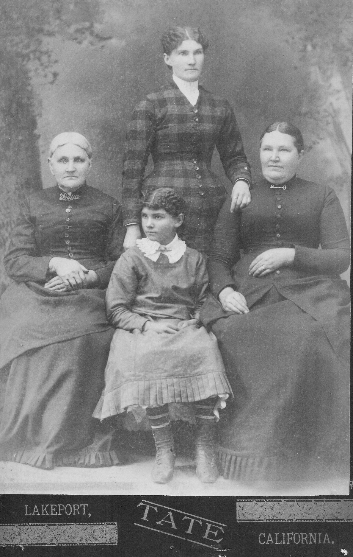
Nancy Atlantic Stephenson Bahwell (standing) with her mother Lydia Smith Stephenson Flagg, her niece Mary Blincoe, and her sister Armilda Josephine Stephenson Blincoe. Date unknown.
It is uncertain when the Bahwells acquired the land on which the Bequette House now stands. The official records indicate that the family lived in Visalia until 1880, when they moved to the property. We can assume that they had acquired the land at least a year or two earlier, and moved there only when there was a comfortable house for Adam, Nancy, and their six surviving children. Both the records and an obituary indicate that the family returned to their home in Visalia in 1881, however, and moved to Three Rivers permanently a few years later after they had added two more children their family.
The Bahwells established an orange grove and plant nursery on the property, and used it as a stopover when herding their sheep into the mountains for summer pasture.
Daily Morning Delta, 17 August 1894 (front page)
At some point, the Bahwells set up a hospitality business on the property. The earliest known references to it date from 1892 when the store was noted on a map. That same year, four soldiers from the 4th Cavalry assigned to protect the new Sequoia National Park partook in a drunken brawl at Bahwell’s, and one received serious cuts on his backside.
At the end of 1892 Nancy died, but Adam and the children kept the hospitality business alive.
By 1894, the Adam and his children were hosting boarders and feeding people on their way to Mineral King for a summer respite. That year they entered into a price war with the neighboring Blossom family, which had just set up a liquor and food stand on the side of the Mineral King road. The price of beer dropped from 40 cents to 10 cents a bottle!
By 1900, Adam considered his enterprise a veritable hotel, and his primary occupation that of hotel keeper. He died in 1901, and the land went to his son Charles Franklin before being acquired by John Allen MacKinnon and his wife Bessie in 1909. It appears to have been a “friends and family” transaction. Bessie was a Three Rivers resident and the daughter of Water Fry. Fry was a civilian ranger for Sequoia National Park and a close friend of the Bahwells. As testament to their friendship, when Charley Bahwell had a diabetic emergency in 1915, the Frys cared for him in their home until he died.
Part 2: The Bequettes
In the late 1840s and 1850s, an extended family of Bequettes migrated west from Missouri to join the gold rush in northern California. There the Bequette family settled and grew until several members migrated south to Tulare County in 1857. They put down roots in the Farmersville area where they amassed large quantities of land and eventually entered into the world of high finance as self-described capitalists.
When the Mineral King mining rush commenced in 1873, however, the Bequettes couldn’t resist.
Paschal Bequette Sr. (1806-1879), his son Paschal Jr. (1845-1925), and his nephews, the brothers Charles Clovis (1834-1916) and Cyprian Ladislas Bequette (1825-1875) made their way to Mineral King in June of 1874. Rather than prospect the slopes and canyons surrounding the Mineral King valley, however, they climbed over Farewell Gap. There they established Bullion City.
Although there is no record that the Bequette woman partook in the mining, women did live in Bullion City. One such woman was Harriett Hill (1834-1887), who became the first woman to sign her name on a mine claim in the Mineral King Mining District at a time when female ownership of mine claims was extremely rare. Perhaps as an indication of their progressive outlook, the Bequettes partnered with Harriet.
Although the Bequette family actively mined the area until the mid 1880s, the untimely death of Cyprian Ladislas in 1875 ended his branch’s involvement in mining. The family’s attachment to the area didn’t end, however. They established a ranch in the Lemon Cove area, and in 1924, Cyprian’s great grandson Bruce fell in love with a Three Rivers girl. She was Jessie Agatha MacKinnon, the granddaughter of Sequoia National Park superintendent Walter Fry, and the inheritor of the Bahwell land.
Photo of Bruce’s father Cyprien Lamlieslan Bequette (1875-1911), circa 1887. Cyprien was born the year his grandfather Cyprian, co-founder of Bullion City, died. The photographer was E.M. Davidson of Visalia. (Courtesy of Peter Neeley)
Part 3: Jessie’s Story
The following is excerpted from “A History of Woodlake Union High School – The Woodlake 11: Class of 1924,” by John Elliott (published in 1994, in cooperation with the Three Rivers Historical Society).
Jessie Agatha MacKinnon Bequette: I was born September 11, 1906, in the Pollasky Depot in Fresno. My parents, John and Bessie MacKinnon, lived in a small apartment upstairs. My father was employed by the San Joaquin Valley Railroad.
In 1907, we moved to Saskatchewan, Canada, where my father homesteaded a wheat farm. My mother later told me that the winters were so cold there that the milk would freeze when it was rushed from the barn to the house.
After two years of hard times, we moved home to Three Rivers [where her mother Bessie Fry MacKinnon was raised]. We lived for a time with my grandparents, Walter and Sarah Fry, while our house was being built a mile or so south of their place [on the old Bahwell property].
In 1910, we moved into our new house. It was the nicest home in Three Rivers and, I think, the only one with an inside bathroom. That was the same year my sister, Edith, was born in Fresno.
That wonderful home burned in a tragic fire in August 1914. My father died in that fire trying to save the family piano [a wedding gift from John to Bessie].
My [pregnant] mother, too depressed to stay in Three Rivers, moved with Edith to Tulare. That was the time, when I was seven years old, that my grandfather, Walter Fry, took charge of my upbringing. [She was living there when Charley Bahwell died in the house under Walter’s care.]
Some of my fondest memories are the Sequoia National Park inspection tours made on horseback as a youngster with Grandpa Fry. Each summer, we would start up the South Fork, crossing Hockett Meadow northward via the Tar Gap trail to the Montgomery cabin in Mineral King.
My first trip up the Colony Mill Road, the main route to Giant Forest before the completion of Highway 198 and Generals Highway in the 1920s, was in Grandpa’s Model T. Grandpa bought his first auto through the mail and learned to drive in his 40-acre pasture [near present-day Hawk Hollow Drive].
It was wonderful living at Grandpa’s house. It was the heartbeat of Three Rivers. There were lots of bedrooms; one on the first floor was his office while he was superintendent of Sequoia National Park [Walter Fry was the first non-Cavalry superintendent of Sequoia, 1912-1920].
The second story was a large, open room. It was great for parties and dancing.
I went to Sulphur Springs School from 1912 until 1920. The school was located north of the main river on what was then the Ogilvie ranch. We walked to school, crossing the river on a footbridge.
In all my high school memories, Senior Sneak Day [1924] had the biggest impact on my life. That was the day we put the big “W” on the hill above Woodlake, then went to Terminus Beach [present-day Terminus Dam at Lake Kaweah] for a picnic.
On that day, I noticed a handsome fellow named Bruce Bequette, who was playing golf nearby. Bruce had graduated from Woodlake High School in 1919, so he joined our class at the picnic.
Six months later, I married that man. We first lived at the Pogue Hotel in Lemon Cove [present-day Lemon Cove Women’s Clubhouse]. Bruce later got a job in Sequoia National Park. We had 43 wonderful years together.
* * *
In 1926, Bruce and Jessie built their Three Rivers home on the old Bahwell property where Jessie’s parents’ home had been.
Following, perhaps unknowingly, the course set by the Bahwells, they established hospitality services. They built an adjacent structure that became Bequette’s Gift Shop (1953-1967). There was also a gas station and a plant nursery where, during Bruce’s National Park Service career, he worked on a botanical project that shipped giant sequoia seedlings for experimental planting throughout the world.
In 1967, Bruce died suddenly from a heart attack. Jessie closed the gift shop and it remained vacant until 1975. That year it was purchased by Jeanette Barton, Jane Cheney, and Nancy Campe and became Mountain Arts, a gift shop and weaving store, for the next 20 years. In 1996, the business was sold and became Gallery 198 for one year. For the past 20 years, it has been, fittingly, the home of the Three Rivers Historical Museum.
Jessie resided in her little white house on the hill for 68 years, moving to Visalia in 1994 at the age of 87 to be near one of her nieces.
She and Bruce never had children.
Jessie died in Visalia on April 9, 2010.
Part 4: Preservation
The Three Rivers Historical Society purchased the 2.5-acre Bequette property in 2012. Since that time, the home has been under renovation.
Currently, it is in the process of being furnished with period pieces, including some of the Bequettes’ belongings, donated by nieces Joan Thomsen and Rachel Caggiano (Edith MacKinnon Perry’s daughters).
Three of Jessie’s dolls from childhood are in a glass case. A hutch in the dining area contains the couple’s Depression glass. A roll-top desk belonged to Jessie’s mother, Bessie; a barrister’s bookcase was Walter Fry’s. A treadle sewing machine belonged to Jessie’s sister, Edith Perry.
There is also a wood cookstove, a spinning wheel, and household furnishings. Still to come will be several themed gardens and a bathroom. The house will be available for group events and artist’s exhibits.
On the grounds, plans include the construction of a two-story barn, in addition to the new replica of the old Bahwell Saloon (the first public watering hole in Three Rivers) and a public-restroom facility.
This massive undertaking would not have been successful without the help of the community of Three Rivers. More than five dozen individuals donated time and/or money to the restoration, as well as public agencies and local businesses.
The house arose out of a community and sheltered people that helped hold that community together and keep it firmly attached to its roots. The Bequette house continues to bring community together, both to gather within its walls and to preserve it and its story.
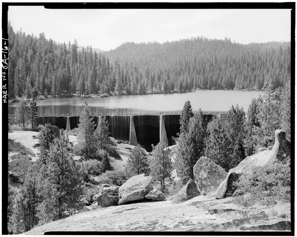
Since the dam that created Hume Lake was built over a century ago, there have been some quick fixes and minor repairs. But the improvements recently accomplished are the most extensive to date and are expected to last another 50 to 100 years.
16 May 2016, The Kaweah Commonwealth
Hume Lake Dam, Sequioa National Forest, Hume, Fresno County, CA (Library of Congress ca. 1968)
Direct descendant of a dam built to create a log holding pond in 1908, the dam that holds Hume Lake has undergone some quick fixes and minor repairs over the last 100 years. But the improvements accomplished in 2016 are the most extensive to date and are expected to last another 50 to 100 years.
In October 2015, after the area was determined to be safe from the encroaching Rough Fire and the reservoir’s water was no longer needed for firefighting efforts, Hume Lake was drained, scaffolding erected, and work began.
After significant grouting in all the cracks and crevices where some seepage was occurring, a Carpi dam lining system was installed. This is a waterproofing geomembrane lining that was installed on the upstream side of the Hume Lake dam and restored watertightness to the entire face.
“It’s a phenomenal system,” said Teresa Benson, Hume Lake district ranger. “We ended up with a complete lining of the former concrete dam.”
The project was completed in March and the lake was refilled. The total cost was about $3 million.
This coming fall the lake will have to be drained one more time for a scheduled maintenance project.
“But it won’t be for as long this time,” said Teresa.
History of Hume Lake
Construction on the dam began in June 1908 when the Hume-Bennett Lumber Company created Hume Lake as an 87-acre log-holding pond. This area of what has been Sequoia National Forest since July 1908 was formerly the site of extensive logging operations.
After working their way through Converse Basin, where they felled every giant sequoia except for one, the lumberers were looking for new timber stands to harvest. They settled on trees to the east of Converse Basin and built a large sawmill complex.
Working dawn to dusk, seven days a week, crews finished building the dam in 114 days. The cost of construction was $46,541, and the finished dam was 667 feet in length, 61 feet high, and contained eight miles of steel cable reinforcing 2,201 cubic yards of concrete.
The Hume Lake dam was the first concrete reinforced multi-arch dam to be built in the United States. It consists of 12 arches with the upstream faces sloped so water pressure exerted downward keeps the dam stable.
The reservoir provided a year-round water source for the flume that transported via gravity the lumber to Sanger in the San Joaquin Valley below.
Concurrently, work was occurring on a three-story mill complex located below the dam. By 1910, the area included two huge drying kilns, a boiler house, powerhouse, and foundry. The adjacent community had a housing complex, dining hall, post office, and hospital.
And although the logging activity was intense, the expenses of operation and maintenance were high. The mill had a difficult time making ends meet.
On April 8, 1935, the U.S. Forest Service purchased Hume Lake, Converse Basin, and surrounding lands totaling more than 20,000 acres for $319,276.75.
Today, Hume Lake provides water for the nearby campground, privately held cabins, Christian camps, fire suppression, and recreation, including fishing, swimming, and non-motorized boating.
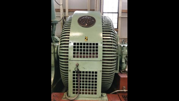
A glimpse inside Three Rivers’ Power House Number 2 reveals equipment installed when the power house was constructed in 1905–equipment that still provides power to the region today!
By Sarah Elliott, 2 April 2019, 3RNews; editorial update 2 April 2021
Three Rivers hosts three historic hydroelectric powerhouses, which provided the electricity that contributed to the growth of agriculture in the valley below and its eventual designation as “the world’s breadbasket.”
Power House Number 2, built in 1905 by Mt. Whitney Power & Electric Company, uses flume-fed water pressure to produce the kilowatts necessary to power 1,000 homes with clean, renewable energy. This is accomplished using some of the original equipment from 114 years ago (in photos).
Taken over by Southern California Edison in 1917, the hydroelectric system as a whole consists of four check dams at Mineral King (Franklin, Upper Monarch, Crystal, Eagle), two diversion dams (Middle Fork, Marble Fork), three forebays, many miles of flumes, and three powerhouses: Powerhouse No. 1, built in 1899, located on Highway 198 near the Mineral King Road; Powerhouse No. 2, described above; and Powerhouse No. 3, built in 1913.
This summary account of the popularly-accepted history of Lemon Cove is typical of community histories in that it centers on one Euro-American man, in this case, J. W. C. Pogue. Look for the missing voices.
By Sarah Elliott, 20 April 2019, 3RNews
The former Pogue home and hotel, now the clubhouse of the Lemon Cove Women’s Club and on the National Register of Historic Places.
Lemon Cove, nestled in the foothills between Woodlake and Three Rivers, was first called Lime Kiln due to the lime deposits discovered in the vicinity in 1859. Lime Kiln Hill, an anchor point for the present-day Terminus Dam at Lake Kaweah, was the boundary between the Wutchumna and Potwisha Indians who lived along the Kaweah River.
The history of the community of Lemon Cove begins with James William Center (J.W.C.) Pogue (1839-1907). The Pogues came to California in 1857 and settled near Venice Hill (between Woodlake and Lemon Cove) in Tulare County in 1862.
After the flood of 1868, they moved to Dry Creek (north of Lemon Cove), where Pogue planted oranges and lemons. Until then, lemons were considered too tropical to grow in the San Joaquin Valley. When the family moved to what is now Lemon Cove, the citrus trees were transplanted successfully.
The Pogue home, built in 1879, served also as a hotel for many years and is now the headquarters of the Lemon Cove Woman’s Club.
Pogue Hotel, 1879-1903
The Pogue Hotel, originally called “The Cottonwoods,” was constructed by a ranching partnership formed in the 1870s by J.B. Wallace and C.W. Crocker of San Francisco, and J.W.C. Pogue, resident superintendent. At the height of the Mineral King silver rush, the Wallace, Crocker, and Pogue Company was organized for the purpose of buying ranch land to raise livestock.
Initially, the company grazed sheep; operations were expanded to cattle and grain farming. The ranch was known as the “Cove,” the area being well-suited for cultivation of grain.”
In 1881, Wallace died and the company was reorganized. Mrs. Wallace took her one-third, over 3,000 acres in the western part of the Cove, and the property became known as the Wallace Ranch.
J.W.C. Pogue purchased the Crocker share and became sole owner of the hotel and 6,000 acres. J.W.C. Pogue, who served two terms as a Tulare County supervisor, lived to see his vision of citrus groves in the land he pioneered. He was solely responsible for the introduction of lemons to Tulare County and the development of the townsite of Lemon Cove. It was evident that Pogue had discovered an ideal place for lemons. In 1885, he exhibited lemons at the Los Angeles Fair and won a blue ribbon.
The Pogue Hotel — as the two-story, 13-room lodging facility was known after the consolidation — accommodated travelers on the road to the Mineral King mining district and the Kaweah Colony. It was here that the Mineral King stage changed from horses to mules for the long uphill journey.
Timber teamsters, tourists, and other travelers found the hotel a convenient stopover. Meals were served to diners even if they weren’t overnight guests, and the hotel soon became a popular gathering place.
In 1894, J.W.C. Pogue surveyed 15 acres of the family ranch, dividing the parcel into 48 town lots. He named the town Lemon Cove, though later the post office changed the spelling to “Lemoncove” to avoid confusion with Lemon Grove.
The Pogue Hotel and Store (located on a lot north of the hotel and eventually contained the community’s post office) evolved as the town center and, in the early part of the century, the town’s population grew to 500. Although there was a hotel, store, post office, blacksmith shop, and more, there were no saloons. J.W.C. Pogue, who never smoked or drank, outlawed them within the town limits.
Montgomery-Pogue House, 1904-1936
In 1904, Nora Alice Pogue (1884-1984), the youngest of J.W.C. and Melvina Blair Pogue’s nine children, was deeded the Pogue Hotel, which had been her birthplace. In that same year, she married Dr. Robert Bruce Montgomery (1880-1966), Lemon Cove’s first resident physician and justice of the peace.
The Montgomerys remodeled the hotel and changed it into a single-family residence. After the hotel was converted to a residence, a small business block was developed in the vicinity.
James William Center Pogue returned to live with his daughter and her husband during the last years of his life. In 1907, he died there at the age of 68.
Lemon Cove Woman’s Clubhouse, 1936-present
In the 1930s, there was a consciousness on the part of local residents as to the historical importance and community function of the former hotel and current home. In 1936, Nora Pogue Montgomery, who had been a founding member of the Lemon Cove Community Club in 1924, deeded conditional use of the house and the one-quarter acre of land on which it is situated to the club.
This conveyance coincided with the official charter of the community club as the Lemon Cove Woman’s Club. The deed stipulated that the property would revert back to Pogue heirs in the event that the building was no longer used by the Lemon Cove Woman’s Club.
Today, the club still meets in this former hotel and home, which was listed on the National Register of Historic Places in 1991. The historic setting of the Pogue Hotel has changed very little since its construction in 1879.
The original decision as to building placement was influenced by the location of a nearby wagon road that connected Visalia and Mineral King. In later years, the old county road was improved and realigned, and the historic building is now on the east side of and adjacent to State Highway 198.
Lemon Cove has remained rural and is surrounded by cattle ranches and citrus groves. The small community has a post office, fire station, elementary school, two churches, small market, mini-mart, two 24-hour gas stations, a produce market/restaurant, citrus stands, and a campground.
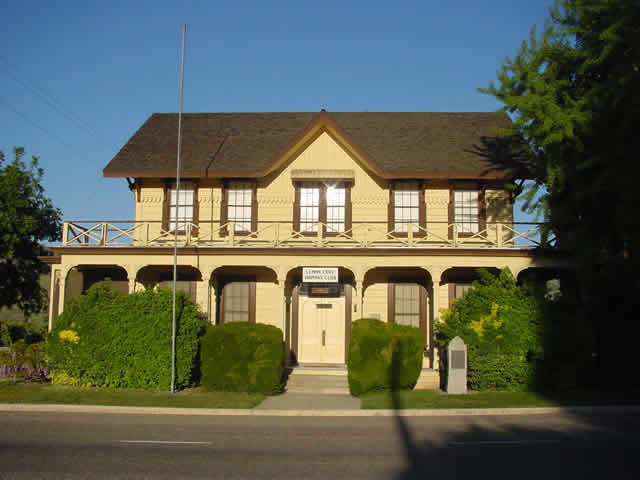
There were houses built in Three Rivers, Calif., before it, but none have outlasted the ranch house on North Fork Drive that was built in 1880. And, in that time, the oldest home in Three Rivers, located at the confluence of the Kaweah River’s Middle and North forks, has been owned by just two families — the Bartons, then the Pierces.
Part One: The Builders
This segment was written by Sarah Elliott, whose paternal great-great-grandfather built the house.
On April 30, 1865, the Barton family left Davenport, Iowa, and began their 2,000-mile journey by covered wagon across the plains.
James and Susan Barton and their nine children — ranging in age from 22 years to nine months — arrived September 6 in the California mining town of Columbia, where they met up with James’s younger brother, Stephen, who had come West in 1854.
The Bartons stayed in the Mother Lode mining region for just a month before heading south to Visalia. In his possession, James had a land grant for 120 acres that had been given to his father in partial payment for his service in the War of 1812.
Upon location of the parcel, situated west of Elderwood, son Hudson later said: “A poorer piece of ground we couldn’t have found.”
The family then homesteaded in the Auckland area, in the foothills north of present-day Elderwood. It was here where their 11th child, Milton Montgomery “Mont” Barton, was born on Feb. 14, 1867.
James and Susan later moved to Three Rivers after their son, Orlando (1847-1917), had acquired some property on the North Fork in 1878. They lived in a log cabin along the North Fork river near present-day Kaweah River Drive until they completed their ranch house in 1880.
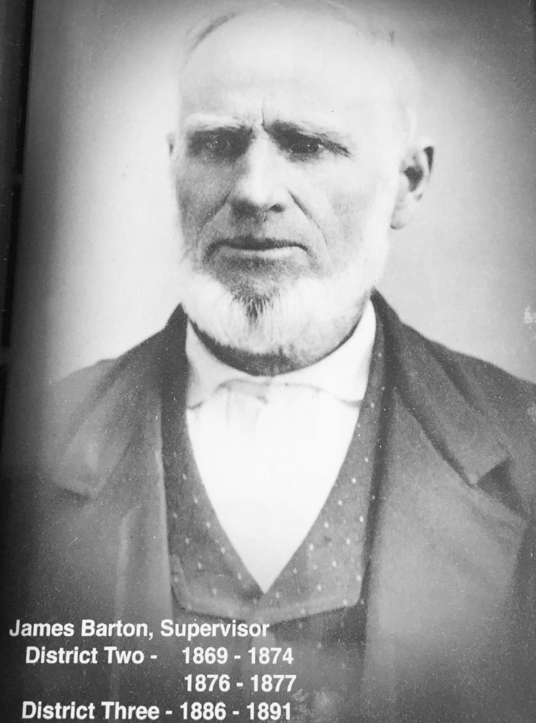
James Barton, 1819-1912
James was a member of the Tulare County Board of Supervisors for 17 years. He would walk to and from Three Rivers to attend the meetings in Visalia, a distance of 35 miles one way.
In 1888, Mont married Harriet “Hattie” DeMasters. The Barton house and 120 acres were subsequently deeded to Mont.
On Sept. 16, 1910, Mont was tragically killed while installing the first electric irrigation pumps in the area for the Elderwood Citrus Development Company, owned in part by his brother, Jason. The commercial use of electricity was largely untried and Mont’s electrocution was caused by a lethal combination of water, electrical lines, and a misinterpreted signal that caused a switch to be thrown too soon. He was the first person to be buried in the newly established Three Rivers Cemetery.
Susan Barton died Jan. 19, 1912, on the couple’s 69th wedding anniversary, at the age of 88. Less than eight months later, on Sept. 1, 1912, James died at the age of 93 at his beloved Three Rivers ranch. Both are buried in the Three Rivers Cemetery. Hattie and her youngest of four children, daughter Lois, left the Three Rivers ranch and resided in Elderwood. In 1920, when Lois was 12, they moved to San Jose where Hattie felt she could ensure a better education for her daughter.
Lois was the first in the family to graduate college, earning a master’s degree in chemistry from Stanford University.
James and Susan Barton are my great-great-grandparents. They are the first of what has now been six generations of Bartons to reside in Three Rivers, all on land originally owned by them or their children.
* * *
The next owners of this historic ranch house were James and Julia Pierce, beginning in 1911. Today, the property continues to be owned by Pierce descendants.
Part Two: The New Owners
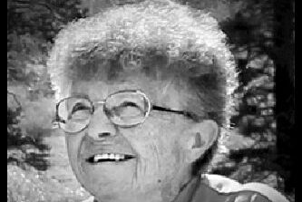
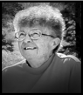
This segment was written by Juanita Tolle (1931-2017), who lived on the ranch with her mother and grandparents from the age of three months until she was 12.
My grandfather, James H. Pierce, was an oil company superintendent in Coalinga. In 1910, he and his wife, Julia, made a vacation trip to Giant Forest.
They traveled to Lemon Cove by train then made the trip up the North Fork road by horse-drawn stage. The stage stopped at the Mont Barton ranch for lunch. The North Fork road passed directly in front of the ranch house.
Juanita Tolle, 1931-2017
(The front of the ranch house faces the river and the North Fork road used to pass within 30 feet of the front door. In 1892, the roadway was moved down slope from the house and closer to the river. As buggies gave way to cars, and cars began to travel faster, this curvy section of road — known as Pierce’s Corner — became notorious for traffic accidents. The road was rerouted in the 1980s and today crosses the ranch behind the house.)
James and Julia fell in love with the ranch and the area. Due to the untimely death of Mont Barton, the Barton family was in the mood to sell, so a deal was made. A deed was recorded June 13, 1911, which transferred the property from Milton M. Barton, et al., to James Henry Pierce.
In the years prior to the formation of the National Park Service in 1916, the U.S. Cavalry came each summer to supervise Sequoia National Park. The troops rode up the North Fork road right in front of the ranch house.
The Hengst family’s cattle were also driven past the ranch house each year on their way to summer forage in the high country. Imagine the dust, bellowing cattle, and shouting cowboys.
Redwood logs that had washed downriver in the flood of 1867 provided ample wood for picket fences that demarcated much of the ranch property. Some sections of this fence remain today.
My grandparents used kerosene lamps to light the house. They cooked on a woodstove — inside in the winter and outside under the grape arbor in the summer. Many a delicious meal was created and served from this woodstove, which is still in the house today along with a supplementary electric stove. The other heat source in the house was the fireplace in the living room. The fireplace had a granite slab as a hearth, a brick-and-mortar chimney, and cast-iron owl andirons to hold the logs.
At bedtime, the family carried hot flatirons or heated rocks wrapped in newspaper to warm their beds in the cold bedrooms. The remainder of the nightly fire was covered with ashes to provide hot coals to start the next morning’s fire.
The foundation of the house includes large flat granite rocks plus occasional sturdy redwood posts to share the burden of weight. A second story was added to the house for more bedroom space, but studs for support were not included.
The upper rooms and porch shake a bit, which adds to the charm of the house.
The kitchen floor creaks and slants, but holds an oak table that can be extended to seat 20 people. Over the years, other floors and doors have sagged and have been shored up by helpful neighbors.
The original paint on the house was maroon with green trim, but little evidence of this remains today. The screened-porch doors were added in 1915 and have been patched with various bits of board over the years.
The plan for domestic water was well thought out. A good spring a half mile up the North Fork road was boxed with redwood and a small iron pipe was laid in the Brundage ditch to keep the spring water cool in the summer and safe from freezing in the winter.
There was another spring below the house enclosed by granite boulders that later became a water supply for the house. The Pierces named their property Rock Spring Ranch.
Mont Barton had built a flume to the washing area to run a waterwheel that operated a washing machine.
We had a three-hole outhouse outside the fence beyond the big walnut tree, complete with spiders and the Montgomery Ward catalog.
The ranch house had an inside bathroom with a claw-foot bathtub. We had no hot water heater so water was heated on the stove.
A large copper kettle made in Pennsylvania was left behind by the Barton family. Grandmother Pierce used it to scald butchered hogs, made soap in it during World War I, and boiled clothes in it. The kettle was later professionally polished and has been a treasure in our family.
We had a telephone on the back porch. To make a call, we cranked the phone to reach the local operator, who was Rena (Alles) Ogilvie during my childhood. Rena would either connect the caller with the person they were calling or, in many cases, could tell you where they were: “She’s up visiting the Petersons” or “They went to town this morning,” etc.
With the ranch, the Pierces inherited fruit orchards that included several acres of apple varieties, citrus, olives, peaches, plums, apricots, pears, nectarines, quince, persimmons, and pomegranates. In the fall, Jim and Julia stayed busy selling apples and cider along with the Savages, Taylors, and Mehrtens.
A large walnut tree outside the kitchen and an almond tree provided annual crops of tasty nuts. As the apple orchards diminished, the orange and grapefruit harvest became the main income.
Jim and Julia Pierce developed a beautiful flower garden of roses, irises, Matilija poppies, zinnias, jasmine, and many other favorites. At one time, Julia had 75 different varieties of iris in her garden. When the irises were in bloom, her garden would be advertised in the Visalia newspaper as a place to visit.
An earth cellar was built under the ranch house. In the winter, melons, cabbages, apples, and squash were stored there. Grandmother Pierce canned dozens of jars of canned fruit during the summer that were stored on the cellar shelves and provided tasty desserts during the winter.
The family had a Jersey cow named “Old Pet,” who produced pans of whole milk that were cooled in the cellar. This milk provided rich cream for churning butter, milk to drink, and to make ice cream in the summer.
To make the ice cream, the family drove their wagon six miles to the Hammond powerhouse to secure 100 pounds of block ice. The ice was wrapped in newspaper and made a cool seat on the ride home.
Part Three: The Pierce family
This segment was written by Juanita Tolle.
My uncle, Bruce, and aunt Mary were born in Three Rivers, joining their two sisters, Frances and Elizabeth (my mother).
Grandmother Pierce was a teacher (graduate of Wilson College in Pennsylvania) and home-schooled her children during the early elementary grades. Then they all went to Sulphur Springs School (today, the private residence with a bell tower on the south end of Kaweah River Drive) and Woodlake High School. My mother attended UCLA for two years.
I lived on the ranch from the age of three months to 12 years (1932 to 1945) with Mother and Grandmother Julia. Uncle Bruce was there until he left to attend Stanford University to obtain a degree in Mining Engineering and, later, he served in the U.S. Army in World War II.
Aunt Mary was with us until she entered training at the Stanford School of Nursing and later served as an Army nurse in World War II.
Frances had married in 1931 and was living in Washington with her husband.
My mother worked in Visalia and Grandmother Julia (“Nana”) was my primary caretaker. She was an intelligent, dignified, courageous lady with a wonderful sense of humor.
Grandfather Pierce left the ranch in the late 1930s because severe allergies and asthma were severely affecting his health. He lived in Hermosa Beach and later in Banning, where he found the desert climate the most compatible for his health.
In the late 1930s, the back porch was enlarged and screened in to accommodate a wringer washing machine and a flush toilet, and still serves these purposes today. At the time, this was a big step forward in family convenience.
At age 60, Grandmother obtained her California teaching certificate and taught at the CCC camps in Three Rivers for several years. She found this role very rewarding as many of the young men could not read or write and were very grateful to her for teaching them these skills. Her last teaching assignment was in a two-room country school south of Tipton (Hanby School).
Grandmother Julia was creative in arranging transportation for herself between her job assignments and the ranch as she never learned to drive a car. She continued to manage the ranch affairs with help from Bruce, my mother, and local handymen, living there until her death in May 1948.
My mother remarried in December 1944 and we moved to Morro Bay in 1945. After Grandmother Julia died, mother looked for someone to rent the ranch house and oversee the property.
Dale and Virginia Williams rented the house for 18 years (Virginia was a former publisher of the Three Rivers Current newspaper in the 1950s). After they built their own home on Kaweah River Drive, Joe Doctor (the late Tulare County historian and author) and his family rented the house for several years.
Eventually, Joe’s daughter, Julie Doctor, became the primary renter for several more years. When Julie built her own house just upriver and moved into it, she was successful in finding a willing caretaker to live in and care for the ranch house.
Billy Hancock is the current caretaker and has proved to be a very satisfactory, caring occupant. Julie still oversees the property and pastures her horses there.
After Grandmother’s death, the ranch was divided amongst the four children. Frances and Mary gave up their shares to Bruce’s wife, Helen, and her sister, Charlotte.
Mother and I shared a quarter interest, even though Mother did the lion’s share of the business affairs. After Bruce’s death, Helen and Charlotte wanted to sell the ranch property, and all but 8.04 acres was sold in the early 1980s.
Helen retained her share for her two children. I later bought out Charlotte, so the current ownership is Helen Pierce, 50 percent, and me, 50 percent.
The property sale was a very painful process for me because I love this ranch so much. My fond memories are too numerous to include here.
The river is still one of my favorite spots. Many summer hours were spent in the river, diving for rocks and enjoying the cool relief from the summer heat. Mother and I shared a bedroom and the sound of the river lulled us to sleep each night.
Unfortunately, more recent floods have drastically changed the configuration of the “swimming pool” in front of the ranch house, and the main river has intruded into the North Fork.
Grace Alles spent many summers at the family cabin at Atwell Mill. From her cabin, Grace could signal with lights to her sister Rose, who for some years was stationed at the Cahoon Rock Fire Lookout near Hockett Meadow, about 10 air miles away.
By Sarah Elliott, 3 September 1999, Kaweah Commonwealth
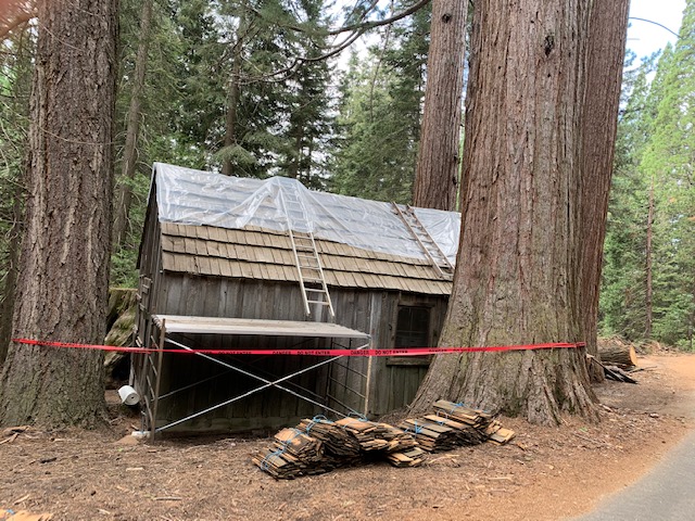
The Alles cabin is one of many historic remnants in the magical Mineral King area of Sequoia National Park that gives visitors a glimpse of late 19th and early 20th century life, a time that is so different, so far removed from today. The board-and-batten cabin, built in 1901, has been open to the public on Sunday during the past two summers.
The cabin is located 19 miles up the Mineral King Road from Hwy. 198 in Three Rivers (just before the Atwell Mill Campground) and 4.5 miles before the Mineral King Ranger Station. This Sunday of the Labor Day weekend marks the last time the cabin will be open to the public during the 1999 season.
Although there’s not much to see in the 600-square-foot dwelling, those with imagination and a love of history and the Sierra are transported to a time when the summer residence was a cozy, comfortable home for Philip Alles (pronounced Alice), his wife, Grace Mullenix Alles, and their two children, Rena and Oscar.
Docents, including Milton and Carol Savage and Jim and Jeanette Barton of Three Rivers, have worked tirelessly this summer to contribute to the upkeep of the cabin and restore the living quarters back to how the cabin by the Mineral King Road looked when Grace was in residence. The only thing that could keep Grace from the cabin every the summer was her death in 1981.
This summer (1999), with the help of National Park Service staff at Ash Mountain, a wood stove was delivered to the Alles cabin, a near-replica of the one Grace prepared meals on for her family, many guests, and sawmill workers for so many years.
Family ties
Philip and Grace Alles‘s daughter, Rena, was born at the family cabin in 1907. Rena married Fred Ogilvie and lived at the junction of South Fork and Old Three Rivers drives, near her parents’ home.
After living her entire life in Three Rivers, Rena moved a few years ago to the Bay Area to be near her daughter, Alice Noreen Ogilvie Schwartz. Bud and Dorothy Stuart of Three Rivers were visitors in the Alles cabin on a recent Sunday. Shirley Devol, who has a cabin in Mineral King, was the hostess that day and had a wonderful time listening to the couple’s reminiscences and taking notes.
Bud and Dorothy were married June 3, 1944, and honeymooned at the Alles cabin. The Stuarts became part of the family when Bud’s sister married Phil and Grace’s son, Oscar.
Hal Boley was another recent visitor. He passed by on his way to Hockett Meadow with his son, Tanner (a fifth-generation Alles), and Tom and Isaac Warner for a Boy Scout outing. Hal, too, has many memories of “Aunt Grace’s” cabin, and remembered the White wood stove and the cooler, accessible from inside the cabin but with the back side extending over the deck, covered with wet burlap bags for insulation, in place of the window that is now there.
Hal is the grandson of John Alles (1876-1957) and Rebecca Epperson Alles. John was Conrad and Christina Alles’s seventh child of 10 and brother to Phil Alles. He and Rebecca had three daughters — Thelma, Dorothy, and Lois.
Dorothy is Hal’s mother and Thelma, who has lived in Three Rivers much of her life, is matriarch of the Crain clan.
Hal’s new granddaughter, Savannah, is the sixth generation of the Alles family to reside in Three Rivers. Thelma’s granddaughter, Holly Crain- Peltzer, who also lives in Three Rivers, is a fifth-generation Alles.
Mullenix and his mill
Grace Alles has ties to the Atwell Mill area of Mineral King that began when her father, lsham “Doc” Mullenix, a Three Rivers pioneer, built the mill, which opened in 1873. It is no coincidence that this is the same year of the silver rush in Mineral King, and three mills were built in the vicinity to provide lumber to brace the mines and build dwellings.
The mill never proved profitable due to the same reasons mining in Mineral King could never pay. The location was too remote and the method of obtaining the product — in the mill’s case, giant sequoias — proved too difficult to cut. But Grace spent her childhood summers in this high mountain industrial environment, even receiving some of her schooling there.
In 1886, lsham sold his mill to A.J. Atwell, a retired judge from Visalia. Atwell also built cabins and a camp to help make his investment more profitable.
In 1891, Atwell leased the mill to the Kaweah Cooperative Colony, the utopian group headquartered on the upper North Fork in Three Rivers that had previously set their sights on the Giant Forest for its promise of timber. They were thwarted in those efforts in 1890 by the creation of Sequoia National Park.
In 1897, Mount Whitney Power Company leased Atwell’s Mill. The company felled giant sequoias to create more than one million board feet of lumber, which was used to build the flume from Oak Grove to Hammond near Three Rivers, over 30,000 feet in length (5.7 miles).
Most of the sequoia stumps at Atwell Mill that line the Mineral King Road and encompass the present-day campground are a result of this massive effort that, in less than one year, built the flume and the first hydroelectric station in Three Rivers.
In 1902, Judge Atwell sold the mill to Henry Alles, the eldest son of Conrad and Christina Alles and Grace Mullenix Alles’s brother-in-law. Henry was the first of the Alles family to emigrate to Three Rivers, convincing his parents and nine siblings to follow. They homesteaded land in 1885 on the South Fork of the Kaweah River.
Henry was born in 1866 and died in Three Rivers in 1940. Prior to owning the mill, he was the Mineral King stage driver, hauling guests, freight, and mail to and from the alpine valley.
The Alles cabin on the Mineral King Road at Atwell Mill. The rug on the porch was handmade by Grace Alles.
A small village had grown up around the mill site. Phil and Grace Alles moved into their Atwell Mill summer cabin in 1901, directly up the slope from the operating sawmill.
addition to working with his brothers at the mill, Phil Alles began another business in 1917. He operated an “auto stage,” which left Visalia every Monday, Wednesday, and Friday at 1 p.m., stopped for the night at Lake Canyon, built by the Grunigen family in the 1890s, and arrived in Mineral King at 11 a.m. the following day.
He would spend part of Tuesdays, Thursdays, and Saturdays, and all day Sunday with his family at the cabin before his return trip to the sweltering San Joaquin Valley for his next fares.
In 1920, the final sale of the mill occurred. It was purchased by a Seattle resident, a representative of the National Geographic Society, who donated the property to the National Park Service.
The mill still operated for a decade more, off and on, to process some of the timber that was felled during its heyday. The Civilian Conservation Corps dismantled and removed the mill about 1939, leaving a part of the iron steam engine, which now commemorates the former site of the mill, located at the edge of the meadow about 500 yards below the Alles cabin.
The Alles name is no longer heard much around Three Rivers. Of the 10 children of Conrad and Christina Alles, all raised and educated in Three Rivers, there were six boys and four girls.
Three of the sons — Henry, Conrad, and Adam — never married. Phil and Grace Alles had one son, Oscar, the only male to carry on the Alles name. Oscar and his wife (Bud Stuart’s sister) had one daughter together.
The Mineral King Road was realigned later from where it used to pass by the mill to its present location within a few feet of the front door of the Alles cabin. Upon Grace’s death, the cabin reverted full ownership to the Park Service, and the little cabin in the middle of the road is what’s left of a fledgling town and business venture in the Mineral King wonderland of 100 years ago.
Historic cabin gets a facelift with National Park Service restoration
By John Elliott, 3 September 2020, 3RNews
During the last few weeks, the historic Alles Cabin, built in 1901, is getting a badly needed facelift and restoration. For nearly three decades, that specialized preservation of the park’s historic resources would be undertaken by Thor Riksheim and his hand picked preservation crew. But Thor, who had long been recruited to work in other national parks, retired from the NPS last year and the search is on from within to find a replacement to fill some iconic work boots.
Riksheim was the last of a vanishing breed with a vast knowledge of historic materials — where they could be procured or how they could be reproduced. Add to his 25 years experience in Sequoia and Kings Canyon National Parks, an uncanny ability to solve problems. And what made Thor indispensable was that was equally adept in the front country or the wilderness.
With each passing year, the back log of historic resources in need of restoration grows in number. Several in the maintenance department, at Sequoia and Kings Canyon National Parks, have given the restoration work a try. It’s not the kind of work, long days in remote places, often in the backcountry, that’s for everyone. But meet Mike Varela, a local guy who grew up in Woodlake, lives in Three Rivers, and for the past 12 years has worked in the maintenance department at Sequoia and Kings Canyon National Parks.
Varela is the work lead on the Alles Cabin restoration, his first historic preservation project. He would be the first to admit that he’s no Thor. But with a reverence for historic resources and willingness to learn, Varela said, he would be all in on doing more of this type of specialized work.
For the Alles Cabin restoration, Varela was quick to point out all the help he got in learning some of what is involved in historic restoration. Brook Stiltz, who worked with Thor, taught Varela how to mill and make the cedar shingles. Maintenance staff from Lodgepole and Grant Grove shared their expertise too.
Varela hopes there are more many projects like the Alles Cabin in his future. And maybe, Sequoia and Kings Canyon National Parks just might have found their next Thor and his magic hammer.
CABIN TALK: Thor Riksheim, (left) work leader of the Cabin Creek restoration project in 2009 in Sequoia National Park, hears tales of ranger days from Jim Barton of Three Rivers, who was stationed there as a seasonal ranger from 1959 to 1961.