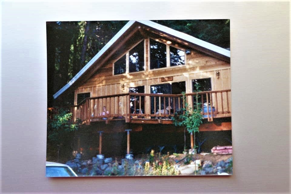
Of the 102 cabins/homes at Sequoia Crest, 55 survived but unfortunately, not the original Rouch cabin built ca. 1946
By John Elliott for 3RNews, 2 October 2020.
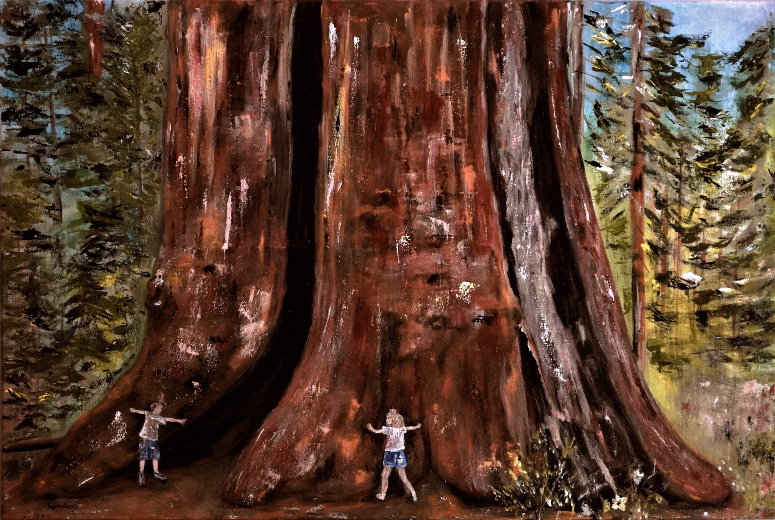
The SQF Complex Fire, that burned over Sequoia Crest and through the Alder Creek Grove, inspired artist Kerry Kaye Davies to create this painting of the Amos Alonzo Stagg Tree, the fifth largest Giant Sequoia on the planet. The Stagg Tree, recently purchased by the Save the Redwoods League, was one of only a handful of giant sequoias on privately owned land and the largest giant sequoia outside of Sequoia National Park.
“We sure have had a wonderful opportunity to have spent even a moment in our mountains. It’s hard to explain to someone the experience if they’ve never had it.” – Kerry Kaye Davies
Of the 102 cabins/homes at Sequoia Crest, 55 survived but unfortunately, not the original Rouch cabin built ca. 1946 Fire on the Mountain
In any disaster, and especially in this unprecedented fire season, there are hundreds of tragic stories. But for those who lose everything, and others whose homes are spared and return to desolation all around, their lives are forever changed.
Countless other persons are attached to these mountain communities across several generations whose lives were shaped by their time spent in these special places. Meet Kerry Kaye Davies, a mother of three, artist, photographer — her heart was broken the moment she heard about the SQF Fire burning in Sequoia Crest.
Davies 52, who now lives in Riverside, was immediately inspired to create a painting of the Amos Alonzo Stagg Tree. The Stagg Tree, see TKC article below, is the fifth largest giant sequoia in the world, and the centerpiece of Sequoia Crest, a cabin community nestled in the Alder Creek Grove of giant sequoias.
Sequoia Crest was a subdivision developed by Sonny Rouch in the years following WWII. The original Rouch cabin was built ca.1946 on Redwood Drive. With the end to logging in the area, it became the real estate office to sell other lots in the tract. After at least one other family owned the cabin, John and Hardie McFadden, parents of Kerry Kaye Davies, purchased the cabin in 1987 and owned it until 2009. During those years it was known as McFadden’s Cottage.
McFadden’s Cottage from 1987-2009. It was the original cabin built by Sonny Rouch ca. 1946 and later the real estate office to sell lots in the subdivision for mountain cabins. It was destroyed along with 46 other cabins in Sequoia Crest; 55 survived.
Kerry Kaye Davies in her own words:
Sequoia Crest won our hearts back early in the 1980’s I was barely a preteen taking art lessons with an art teacher who had a cabin in Sequoia Crest. They had invited our family up to their home and I immediately fell in love with the essence. I later got married and started a family and my parents bought their cabin in 1987 on Redwood Drive.
Kerry Kaye Davies, artist
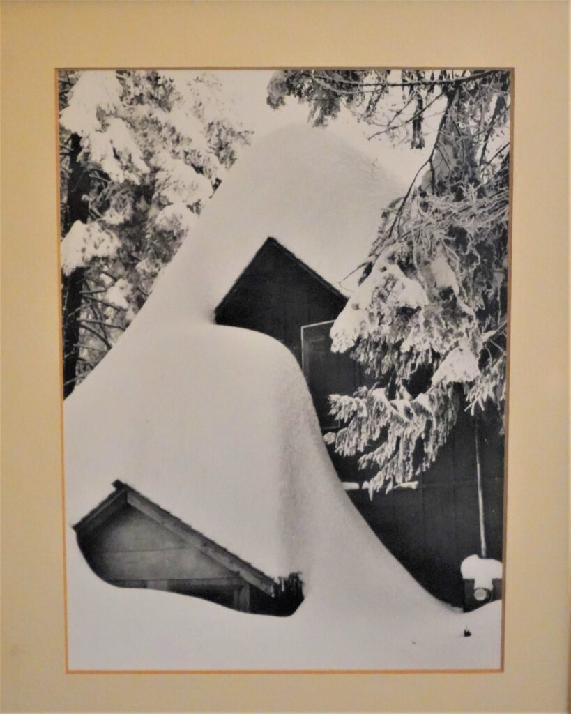
This began our family’s trips to the mountain, and our escape from the business of cities. My three sons and two nieces grew up visiting and living upon the Crest as this place became my parent’s retirement home. When they bought the cabin, it came with two old photographs evidence of a great storm season that had dropped a record snowfall.
There were many tales of that storm (late-1940s), although it wasn’t until 1997 that a measurable amount to match it landed on the Crest once again. My dad told me to take care of these photos because they are special, they were old when we got them, and yes they are indeed special.
Even though my parents did a major remodel of their cabin, the side door and window to the loft were kept the same as this photo. And it was that top window that became our room and our children’s when we visited. As you can see in the photos, it must have been quite a task to dig and to get in and out. I’ve had these photos hanging and in my possession for 30 years . And now, since the fire, they hold even greater significance for the several families who have graced this cabin’s life.
Sequoia Crest cabin covered with snow from an epic storm in the late-1940s.
There are special places upon the Crest — Jordan Peak, Poppy Lake, the Amos Alonzo Stagg Tree, and the embodiment of the Sequoia National Forest itself, that makes us migrate back making memories as evidence of the generations who care and love this mountain. Even though my parents did move several years ago (2009), for 23 years we called this place our second home.
Today, even though we live in cities and towns, our hearts never leave this special place once you have fallen in love with the Crest. You can’t open any of our family photo albums without having some photos of the cabin in them and the evolution of the growth of the kids.
“It feels like salt on a wound to think of the devastation”
Big trees and historic cabins were 2020 Castle Fire casualties in Sequoia’s Dillonwood Grove.
By Sarah Elliott and Laile Di Silvestro for 3RNews, 6 November 2020.
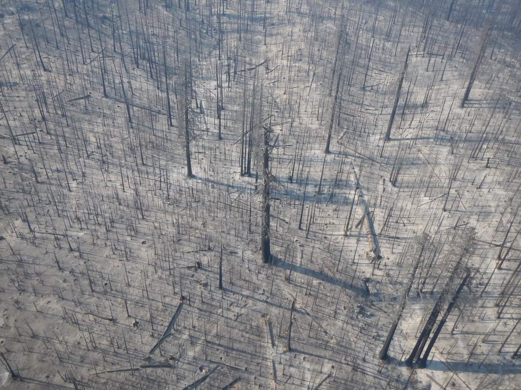
An aerial view of the aftermath of the Castle Fire in the Freeman Creek Grove of giant sequoias. (USDA photo by Curtis Kvamme)
The Dillonwood Grove of giant sequoias, at one time the largest privately owned stand of giant sequoia trees, is located 32 miles from Highway 198’s intersection with Yokohl Valley Road and 6 miles north of Balch Park. Although within an easy day trip of Three Rivers, the grove is the least visited area of Sequoia National Park that is accessible by road. A high-clearance vehicle is necessary to traverse the severely rutted, previously overgrown (but now the vegetation has burned), narrow access road, then it’s several more miles of hiking once the locked entrance gate is reached.
From logging to preservation
Logging started on the lower fringes of Dillonwood around 1865 and continued sporadically until about 1990. In 2001, Save the Redwoods League donated the 1,540-acre grove containing multi-generational giant sequoias to Sequoia National Park after a massive fundraising campaign to purchase the privately held grove. Big Trees and historic cabins
The nonprofit organization brokered a deal to purchase the grove to remove it from private hands and the threat of logging. The purchase price was $10 million. The League raised $5 million to match a $5 million grant approved by Congress that came from the federal Land and Water Conservation Fund.
At the time, Dillonwood Grove was owned by siblings David Reed and Susan Matthews, who inherited the land in the mid 1980s. Their parents, Forrest Reed, a professional forester, and Ruth Moore Reed, whose father worked for Pacific Lumber Company in Humboldt County, bought the land in 1960.
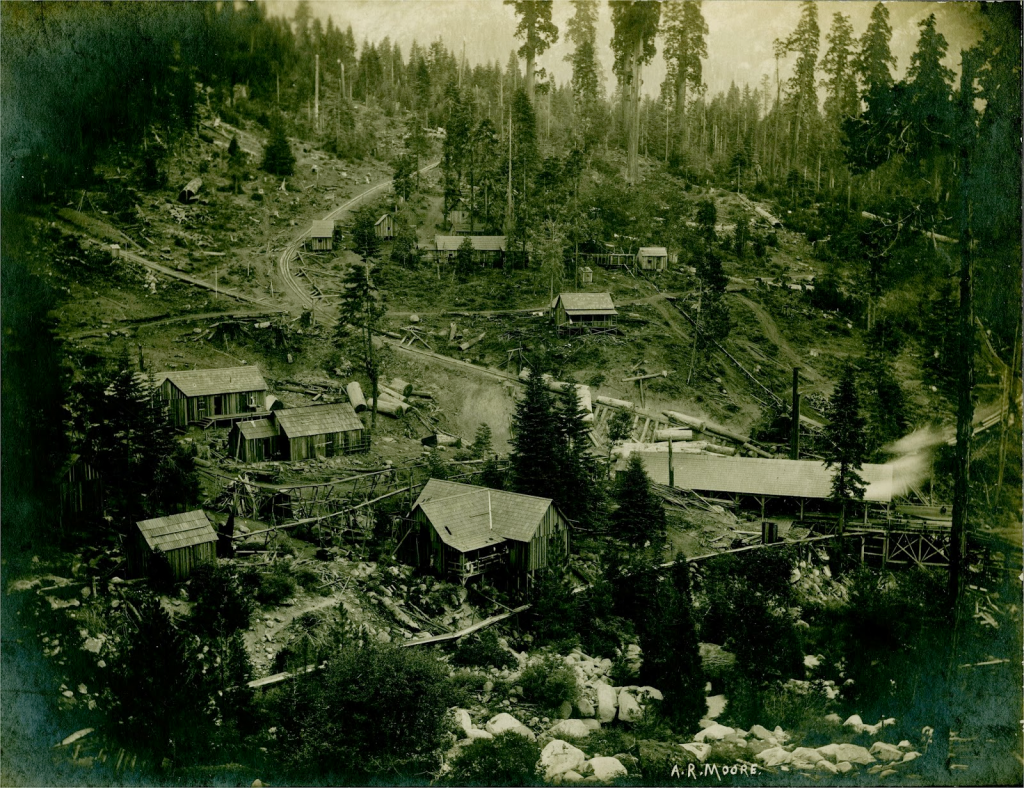
The Dillonwood logging settlement in 1904. Note what remains of a stand of large sequoias at top-center. The road to the left of the giant sequoias that curves down toward the center of the photo is a logging skid path. A “steam donkey engine” would drag cut trees along the skid to the sawmill. There’s a flume running from the sawmill (building at lower right) that was used to transport cut trees down the steep mountainside to Springville. (Photograph by A.R. Moore, Terry Ommen collection)
Giant sequoias and their nemeses
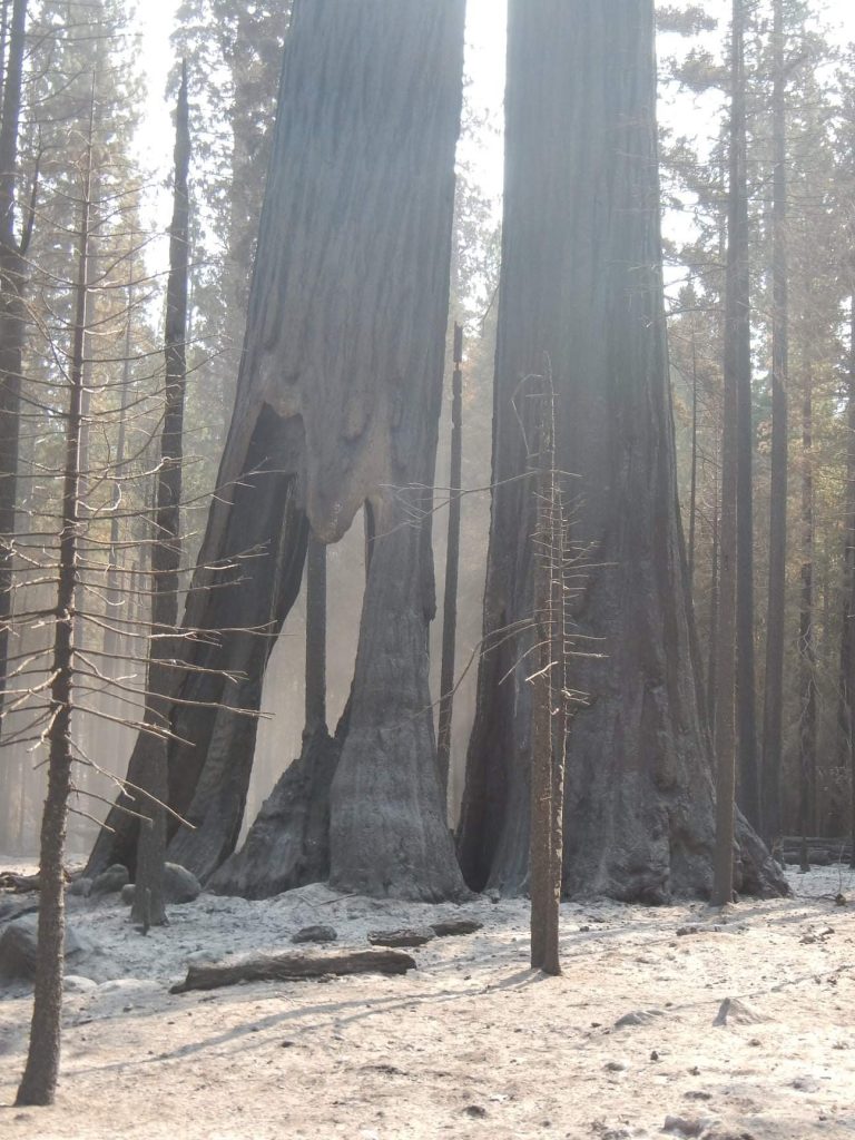
During a century or more of logging in the grove, many old-growth sequoias were felled. All but about 100 large giant sequoias were cut. But it was currently a thriving grove with subsequent generations of sequoias growing where their ancestors were cut and hauled away. And while logging will never occur again in the remote Dillonwood Grove, these Big Trees were recently confronted with another threat: high-severity fire. Big Trees and historic cabins
Even the oldest, largest giant sequoias are vulnerable to intense fire. Most of these ancient trees — at the headwaters of the North Fork of Tule River and bounded on three sides by Giant Sequoia National Monument — have lived through hundreds of fires since before the birth of Jesus Christ, yet modern wildfires are killing them. And while some giant sequoia seedlings will germinate after the fire, new seedlings will have difficulty competing with the shrubs that flourish in response to high-severity fire.
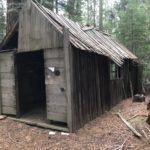
Historic structures decimated
Left over from the Dillonwood logging days were some wooden structures that are now gone. Click on the before-and-after photos below to witness the destruction.
Two other historic cabins in other areas of the Golden Trout Wilderness were destroyed. The Mountain Home Guard Station was built by the Civilian Conservation Corps, ca. 1937-1938, and was in use recently as a recreational rental. The Grey Meadow Guard Station was completed in 1916 for a total construction cost of $90.
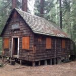
BEFORE – Board-and-batten cabin.
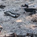
AFTER – Bedsprings and a stove are all that remain from the board-and-batten cabin. (Anthony Rocha photos)
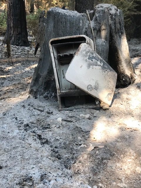
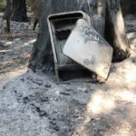
BEFORE – Shingled cabin.
AFTER – A burned-out shell of a vintage refrigerator is all that’s left of the shingled cabin.
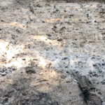
BEFORE – The bunkhouse.
AFTER – No trace remains of the bunkhouse.
Dillonwood’s namesake
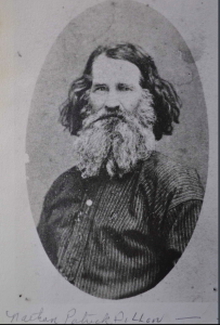
Nathaniel Dillon
Nathaniel Patrick Dillon (1820-1903) was one of the earliest Euro-American settlers in Tulare County. He arrived in 1853 with a few siblings, his wife Zylpha, and three children, one of whom was born en route. They initially entered into the incipient livestock industry and grew grain.
At some point in the 1860s, however, Nathan got into the milling business. His initial mills were gristmills, which converted the area’s corn and wheat into flour and made him one of the most wealthy men in the area.
Zylpha and Nathan had at least 12 children, nine of whom survived into adulthood. They also cared for Elliott and Mary Jane Dillon, the children of Nathan’s younger brother Peter Ewell, who were orphaned in 1866. After Zylpha died in 1886, Nathan remarried and had one more child before his second wife died after being thrown from a wagon while descending the mountain from Dillonwood.
Dillonwood was Nathan’s pinery, which he established in 1875. It is believed to have been his second lumber mill, the first having been established the prior year in Mineral King in the area now known as Faculty Flat. Nathan did not engage in mining in Mineral King, but instead panned for gold in the White River area, founded in 1856 as a gold camp. Originally called Dogtown, then Tailholt, the unincorporated Tulare County community is known today as White River. It is located about 10 miles east of Delano.
Nathaniel Dillon
Members of the Dillon family did stake Mineral King mine claims, however, and Dillonwood served as a wayside during the 1870s and 1880s for miners and adventurers traveling from the Tule River country to Mineral King. At one time, there were plans for the route from Dillonwood to be the main route to Mineral King.
One of the Mineral King miners was Nathan’s adopted niece Mary Jane Dillon, who staked a claim with Anna Mills shortly before Mary Jane was to marry Samuel Miles Gilliam (brother-in-law of Mineral King resort owner Arthur Crowley). Anna Mills was one of the most famous people to camp at Dillonwood. She did so in 1878 while on her way to climb Mount Whitney with the first party of women to reach the summit.
By the end of his life, Nathan was blind. However, his children tended him as well as his land.
Laile Di Silvestro of Three Rivers, historical archaeologist, provided the background on Nathaniel Dillon.
Castle Fire and the sequoia groves in its path
The 2020 Castle Fire burned an estimated 13,600 acres in 10 giant sequoia groves that are located within the Giant Sequoia National Monument of the Sequoia National Forest. Sequoia National Forest has 33 groves total within its boundaries. The Forest Service groves impacted were Alder Creek (shared with private landowner), Mountain Home (shared with State of California), Belknap Complex (McIntyre, Wheel Meadow, Belknap; shared with private landowner), Dillonwood (shared with National Park Service), Middle Tule (shared with State of California), Burro Creek, Freeman Creek, Silver Creek, Upper Tule, and Wishon groves.
Approximately 9,800 acres (35%) burned out of the 27,830 acres of giant sequoia groves in the Monument, with approximately 6,000 acres (61%) burning at high-severity. Where fire burned at lower-severity, or where high-severity patches were small, the fire is expected to have restorative effects on the groves by activating sequoia seedling growth, reducing fuel loads that could fuel future fires, and clearing out small trees leaving more water and light available for remaining plants and sequoia seedlings.
Giant sequoias are a fire-adapted species and need fire to regenerate. Forest fuels in many groves have dramatically changed from fire exclusion and the presence of drought-killed trees of other species, which influences how severely wildfire moves through them. Patches of high-severity fire in the 2020 Castle Fire were likely much larger than they would have been historically, and this could mean an uncertain future for portions of the groves.
The Forest Service will not be able to assess grove impacts until a thorough survey can be conducted. Preliminary satellite data indicate the highest losses of mature giant sequoia trees are in the Belknap Complex and the Freeman Creek groves. Of the recently burned groves, the U.S. Forest Service Burned Area Emergency Response Team found that Alder Creek, Belknap Complex, Dillonwood, and Freeman Creek groves burned at the highest severity, which implies there were also higher losses of trees in those groves.
Note: This article does not include an assessment of the impacts of the Castle Fire on giant sequoia groves within Sequoia National Park. In addition to Dillonwood, nine other sequoia groves in the park are within the Castle Fire’s perimeter: Garfield, Devils Canyon, Forgotten, Clough Cave, Putnam-Francis, South Fork, Cedar Flat, Board Camp, and Homers Nose groves.
Mature sequoias in the Freeman Creek Grove that were severely burned during the Castle Fire. (USDA photo by Curtis Kvamme)
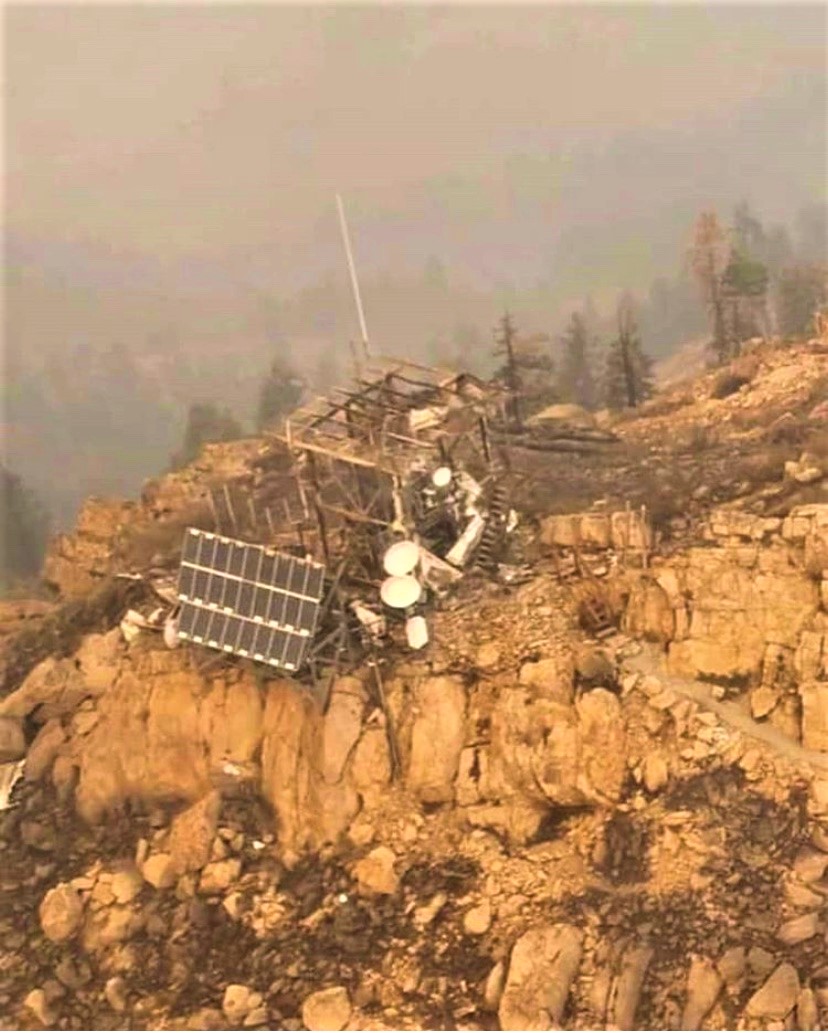
The SQF complex fire destroyed the historic Jordan Peak Fire Lookout in September 2020.
By John Elliott for 3RNews, 8 October 2020.
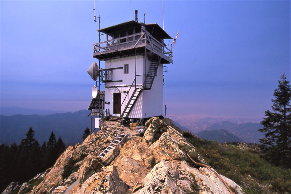
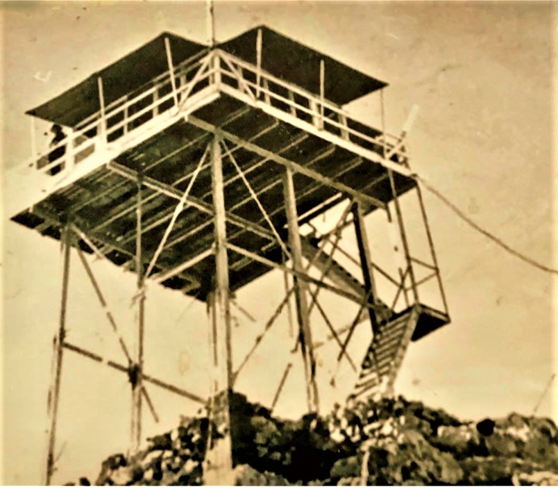
A recent image of the historic Jordan Peak Lookout — destroyed by the SQF Complex Fire on Monday, September 14, 2020. (Mathew Geer photo)
One of only four staffed lookouts left within Sequoia National Forest, the Jordan Peak Lookout was destroyed in a wind-driven firestorm on Monday, September 14, 2020. It is reportedly the oldest lookout site in the Sequoia National Forest.
The Early Years
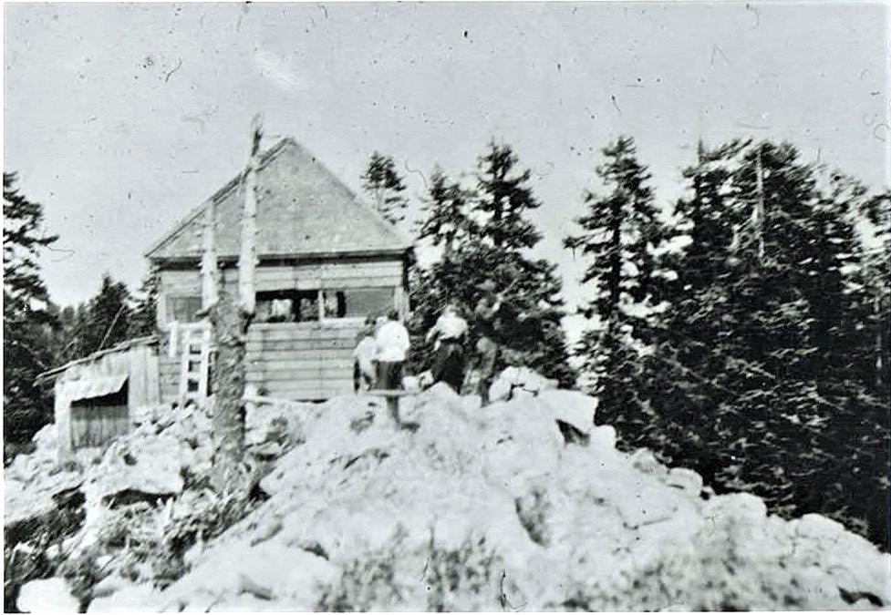
The site was believed to have been used as a lookout in the 1890s prior to the land being designated as national forest. It was located on a granite peak at an elevation of 9,038 feet, a few miles north of Camp Nelson and northeast of Springville. Written accounts exist from 1899 where one observer reported that he could see a dozen fires burning the summer before from the promontory.
There is evidence that the site was officially used as a lookout observation post as early as 1914. In those days, a smoke chaser would ride on horseback to the peak and spot smoke and fires with binoculars then plot the locations on a map using a compass.
Jordan Peak Lookout, ca. 1914. (Photo: Buck Rock Foundation)
The Jordan Peak Lookout location shows up on the oversize 1916 Sequoia National Forest map printed in two sections — a north and a south sheet. It was the first definitive topo map of the Sequoia National Forest boundaries and it showed the location of a lookout at Jordan Peak, but was erroneously drawn in the wrong section.
The name Jordan came from the area’s storied association with John Jordan. Jordan did the route finding and laid out the Jordan Trail in 1861. The trail shortened the route to the Coso Silver Mines near Owens Lake on the Sierra’s east side.
The trail led up Yokohl Creek across the south end of Blue Ridge, up Bear Creek to near Balch Park, then onto Hossack Meadow on the south side of Jordan Peak. Thence on to Kern Flat on the Kern River crossing the main summit of the Sierra via Jordan Hot Springs and Monache Meadows. Portions are still in use today and because of the Jordan Trail, the Union Army had improved access to the Coso district during the Civil War ensuring that the valuable silver would not find it’s way into the Confederate treasury.
The effect on the Jordan Peak area was that many 19th century settlers found their way into the rugged high country around the trail both north and south, a number of whom stayed. It follows that the Jordan Peak Lookout developed a special relationship with those mountain communities that developed around Camp Nelson.
That relationship with the homes and cabins in the area was a special one as a trek up to the summit of Jordan Peak afforded the best views of the Tule River drainage. It was a must for any visitor to the area, and local residents visited the site often to view each changing season of the Tule River country. It was a sightseeing destination, along with the local giant sequoia groves when cabin guests came calling.
The CCCs modernize: An observation post becomes a fire lookout
Jordan Peak Lookout in it’s post 1934 configuration. The steel tower with cab and catwalk was built by the CCCs — Rosevelt’s Civilian Conservation Corps. (Photo: Buck Rock Foundation)
As the years of the 20th century passed, the lookout assigned to Jordan Peak kept watch on a growing number of second homes and summer cabins that were developed in the area. The earliest construction of a 20-foot steel tower and L-4 cab with catwalk was completed in 1934 with the help of the CCCs (Roosevelt’s Civilian Conservation Corps). An extensive remodeling of the lookout structure was completed in 1970 when the existing tower and cab were enclosed with metal siding.
What resulted was a three-story, more utilitarian lookout. The top floor was the observation platform — communications center and work room — the middle floor was the sleeping quarters and at groud level was the kitchen and dining area.
Mark Thornton, an architectural historian who evaluated historic structures for the U.S. Forest Service, dismissed some of the historical significance owing to the 1970 remodeling, so Jordan Peak Lookout was determined not eligible for the National Register of Historic Places. However, the significance of the role that the lookout played in the local community and historical associations with the Jordan Trail, a case could certainly have been made today for a NR listing.
The SQF Complex fire ended any possibility of that ever happening. The lookout’s destruction by this epic wildfire underscores the need to protect cultural resources in advance of these intensifying fire seasons.
In 1994, the Jordan Peak Lookout was officially listed among 506 active and inactive fire lookouts in California by the Forest Fire Lookout Association. The lookout’s destruction on September 14 will be indelibly etched in the hearts and minds of all who knew and visited this special place.
All that remains of the historic Jordan Peak Lookout.