Three Rivers has a history of flooding. The last major flood occurred in 1997. As destructive as it was, however, it is likely to be dwarfed by floods of the future.
Published 24 January 2017, The Kaweah Commonwealth
In this era of recurring drought, a flood disaster seems improbable, but it can and will happen again. And with each passing year, the odds become more favorable. All it takes is weather similar to what Kaweah Country experienced in 1938, 1955, 1966, 1969, 1978, 1983, 1986, and 1997.
That weather entails the buildup of a sizable snowpack followed by a series of subtropical storms that produce 10 to 20 inches of rainfall in a short period. How severe the impacts or property damage from the dramatic rise of the river depends on several factors: rainfall per hour, condition of the streambed, and if the ground is already saturated at the time of peak runoff.
Another factor that must be considered today is the thousands of dead trees that exist in and near the Kaweah drainages. In extended periods of heavy rainfall, dead and downed trees enter the rivers as debris, blocking narrow channels and impeding critical areas of flow.
At the time of the 1997 event, Three Rivers had become complacent to the likelihood of a flood. There had not been a significant high water event on the Kaweah River since the 1980s, and even with a building snow pack at 7,000 feet, a flood event in January 1997 did not appear imminent.
These were the pre-digital days, and even the meteorologists with the National Weather Service in Hanford were reluctant to broadcast anything more than the typical regional small stream flood advisories. For a season that was neither an El Nino or a La Nina, a 10-day forecast in those days was far more problematic than it is today.
For the several days previous to January 1997, local weather watchers monitored reports of heavy rainfall occurring in northern California that began December 26. More than 50 recording stations along the coast and in the northern Sierra recorded historic one-day precipitation totals.
Precipitation and storm damage was heaviest throughout Northern California, including Yosemite National Park. A number of stations recorded 15 to 30 inches of rainfall between December 26 and January 3.
On Thursday, Jan. 2, it rained steadily in Three Rivers during the daylight hours with intermittent periods of “heavy at times.” Three to four inches of rain was recorded in the 24 hours ending January 2, and where it mattered most, at 8,500 feet in the nearby mountains, it rained 11 inches in that same period.
Along North Fork Drive, the river rose steadily toward the roadway. Locals who were here in 1955 recall vividly that when the river crosses North Fork Drive, it’s the “Big One.”
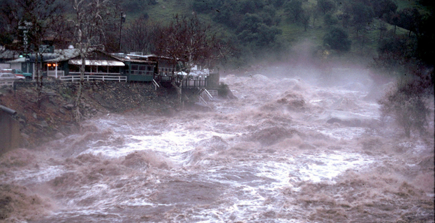
No one could actually see the high water when the January 2, 1997, flows peaked at 11 p.m. At approximately 10:50 p.m., a transformer exploded behind Three Rivers Chevron, producing an eerie strobe light effect then all went pitch black as the power short circuited.
Thousands of cubic feet per second of water were rushing down the Middle Fork channel. Downed trees were careening thunderously from side to side in the rapids, and the sound of boulders being moved by the water’s force and crashing into each other echoed ominously through the canyon.
Water, already lapping at the buildings on the north side of Highway 198, was entering the roadway in a torrent next to the Noisy Water and Three Rivers Market. Another stream was flowing down from Reimer’s Candies on the roadway all the way to Three Rivers School. The two rebellious flows threatened to join forces.
There was lots of property damaged but no structures lost. For comparison, the 1955 flood actually swept away a number of riverfront buildings and houses and was estimated to be nearly twice the size of the 1997 flows that peaked at 11 p.m. on January 2.
The inflow at Lake Kaweah that peaked just before midnight was 56,595 cubic feet per second. In 1955, which was pprior to the building of Terminus Dam in 1962, the peak flow was estimated at 98,000 cfs to more than 110,000 cfs.
During the 1997 event, Lake Kaweah added nearly 60,000 acre feet — 40 percent of capacity — in 24 hours. The lake level rose more than five feet an hour.
As daybreak arrived on Friday, Jan. 3, Three Rivers residents and visitors gathered all along the river and at Lake Kaweah’s viewing points, surveying the damage to roads and bridges and watching the high water recede. In the flood’s wake, there was a bathtub-ring pile of debris that included lots of curiosities, including giant sequoia logs that had made their way down from Giant Forest in Sequoia National Park.
The experts continue to debate whether 1997 was a 30- or 50-year event and even whether 1955 was truly a 100-year event. At any rate, floods will always be a part of Kaweah Country, past, present, and future.
It’s not if these historic events will occur but when.